Article

Spatio-Temporal Variations of the Stable H-O Isotopes and Characterization of Mixing Processes between the Mainstream and Tributary of the Three Gorges Reservoir

1
Key Laboratory of Three Gorges Reservoir Region’s Eco-Environment, Ministry of Education, Chongqing University, Chongqing 400045, China
2
State Key Laboratory of Simulation and Regulation of Water Cycle in River Basin, China Institute of Water Resources and Hydropower Research, Beijing 100038, China
3
Department Key Laboratory of Water Environment, China Institute of Water Resources and Hydropower Research, Beijing 100038, China
4
The Tibet Autonomous Region Hydrology and Water Resources Survey, Tibet Autonomous Region 850000, China
5
College of Water Conservancy and Hydropower, Hebei University of Engineering, Handan 056001, China
*
Authors to whom correspondence should be addressed.
Water 2018, 10(5), 563; https://doi.org/10.3390/w10050563
Submission received: 28 March 2018 / Revised: 19 April 2018 / Accepted: 23 April 2018 / Published: 26 April 2018
(This article belongs to the Section Water Resources Management, Policy and Governance)

Abstract

:
Understanding the runoff characteristics and interaction processes between the mainstream and its tributaries are an essential issue in watershed and water management. In this paper, hydrogen (δD) and oxygen (δ18O) isotope techniques were used in the mainstream and Zhuyi Bay (ZYB) of the Three Gorges Reservoir (TGR) during the wet and dry seasons in 2015. It revealed that (1) Precipitation was the main source of stream flow compared to the TGR water line with meteoric water line of the Yangtse River basin; (2) The δD and δ18O values exhibited a ‘toward lighter-heavier’ trend along mainstream due to the continuous evaporation effect in the runoff direction, and the fluctuations reflected incoming water from the nearest tributaries. The general trend of d-excess increased with increasing distance from the Three Gorges Dam, which indicated that kinetic fractionation was an important process affecting the isotopic composition. The enrichment effect of isotopes was found in the downstream of TGR; (3) Water mass from the TGR mainstream flowed backward to the confluence zone of ZYB via the middle and bottom layers in the dry season, whereas in the wet season, water reversed through the upper-middle layers due to thermal density flows. This study described and demonstrated that the water cycle of TGR was driven by natural environmental variability and operational system, which will provide valuable information for the water resource management and for controlling the algal blooms in the future.

1. Introduction

As one of the largest hydropower projects in the world, the Three Gorges Reservoir (TGR) is located at the upper and middle catchment of the Yangtse River. It is about 660 km long and 58,000 km2 in the watershed area [1]. The water level of TGR was impounded to the elevations of 135 m, 156 m, and 175 m in 2003, 2006 and 2010. Then, the TGR was fully operational with water levels fluctuating between 145 m (from April to September, wet season) and 175 m (from October and mid-April, dry season) annually [2]. It is key to engineering the exploitation and harnessing of water resources of the Yangtse River, which brings many obvious benefits, such as electrical energy, flood control, drought relief and economic development. It also has many negative effects on the environment and ecology [2,3].
After the first impoundment of the TGR in 2003, the water flow velocity decreased and the water retention time increased. It has changed the spatiotemporal distributions of water resources and nutrient compositions in the TGR mainstream and its tributaries, even resulting in the occurrence of algal blooms in some tributaries of the TGR [4,5]. Water circulation is a complex process based on precipitation, runoff and evaporation. However, due to its operation modes, the hydrological conditions of TGR are different from that of ordinary rivers [6]. For example, in the wet season, the rainfall is abundant while the water level of the TGR is lower; in the dry season, the rainfall is insufficient while the water level is higher. Thus, it might weaken the effect of precipitation while strengthening the characterization of runoff on water cycle of the TGR, which would lead to some specific hydrological conditions in the reservoir [7]. Consequently, it is of great importance to explore the processes of water cycles in the TGR to understand the runoff characteristics and the hydrodynamic conditions between the mainstream and its tributaries.
Stable hydrogen and oxygen (H-O) isotopes (denoted as δD and δ18O) can serve as conservative natural tracers in hydrological environments and have been widely used in many aspects of tracing the water cycle [8,9,10]. For example, intensive evaporation enriches the isotopic composition of surface water and this signal has been identified in the downstream rivers [11] and applied to estimate evaporation over large lake systems [12,13]. Xiao et al. [13] reported that the stable isotopic mass balance model was of high precision and very practical in the case study of Taihu Lake. In addition, it is useful to identify water sources and mixing process by tracers of stable H-O isotopes, since different water sources often contain different isotopic compositions. Mortathi et al. [14] detected that the average surface runoff and baseflow contributed to about 30.3% and 69.7% of the Amazon River, respectively.
Since the 1980s, the isotopic tracing technology was used to study the hydrological processes in the catchment of Yangtse River and previous studies have concluded that precipitation, evaporation and inflows of tributaries were the main causes for the spatial variations of H-O isotopes in the Yangtse River [15,16]. In recent years, emerging isotopic studies have focused on the TGR. Deng et al. [17] reported the phenomenon of small fluctuations of deuterium excess (d-excess) downstream the Three Gorges Dam (TGD) after 2008 and inferred that the retention effect of reservoir greatly altered the water cycle. Zhou et al. [11] found that the TGR operation had a certain effect on the isotopic composition of the river water, especially in the dry season. The inflow of tributaries water also significantly influenced the variation of the H-O isotopic values of the TGR water. For instance, the river water in Yichang region was mainly influenced by the tributaries in the north bank, which was originally supplied by the meltwater with highly-depleted H-O isotopes at a high altitude of Shenlong Mountain [11]. In addition, the H-O isotopic technology has been used to analyze the mixing processes and nutrient distributions between the mainstream and its tributaries, like Daning River [5] and Xiangxi Bay [18]. They found that there were significantly layered and bidirectional density currents in the confluence zone and concluded that nitrogen and phosphorus nutrients contributed from the mainstream accounted for more than 80% and 60%, which were regarded as one of the most likely causes of eutrophication in tributaries [5,18]. Nevertheless, few studies have investigated the H-O isotopic variations and runoff characteristics in the TGR mainstream. As such, these studies may not provide full recognition on the TGR.
To complete the knowledge system, this study presented H-O isotopic data of the TGR mainstream and a typical tributary (Zhuyi Bay) in August and November of 2015, aiming to (1) Characterize the water isotope composition of TGR; (2) Clarify the spatial and temporal variations of water isotope composition in TGR mainstream; (3) Investigate the interaction process between the mainstream and tributaries under different climate conditions. We expected that the results would help develop water resource and exert better control over the eutrophication in tributaries.

2. Materials and Methods

2.1. Study Areas and Water Sampling

The TGR area (29°16′–31°25′ N, 106°20′–111°50′ E), mainly controlled by the subtropical monsoon climate, has a mean annual temperature and precipitation of 16–19 °C and 1000–1200 mm, respectively [2]. The TGR mainstream traverses through Chongqing to Yichang City from west to east. The water of 19 sampling points (S01–S19) along the mainstream was taken and analyzed to understand the spatial and temporal variations of H-O isotopes, as well as the hydrological process of the TGR.
To illustrate the interaction process in the confluence zone between the mainstream and its tributaries, a tributary (The Zhuyi Bay) was chosen as a representative to analyze the mixing processes in the backwater area through the H-O isotopes tracer technique. The Zhuyi Bay (ZYB), joining into the TGR mainstream at a 60 degrees angle with small upstream flow, is in the middle of the TGR. It has a length of 29 km, a width of 200–300 m and a watershed area of 153.6 km2, which is characterized by a typical short-narrow tributary and greatly affected by the hydrology of the mainstream [4]. Additionally, frequent algal blooms occurred in ZYB in recent years, which may be related to the low flow velocity, high nutrient concentrations, and the hydrological mixing process between ZYB and the mainstream [4].
The sampling work of ZYB was performed on 26 August 2015 and 26 November 2015. The four sample sites were settled as ZY01–ZY04 from the estuary to the upstream along ZYB (Figure 1). The stratified sampling was taken with the depth of 0 m, 5 m, 10 m, 20 m, 30 m, …, from the water surface to the bottom. The flow velocity was measured in situ with the equipment of Acoustic Doppler Velocity profiler (Teledyne RDI Company, San Diego, CA, USA). Detailed information about the sampling points of mainstream and ZYB is provided in Figure 1 and Table S1. All the sampled water was collected in high density polyethylene (HDPE) bottles (50 mL), sealed by sealing film in situ and preserved in a refrigerator (4 °C) to avoid isotopic fractionation.

2.2. Measurement of H-O Isotopes

Water samples were filtered through 0.45 μm polycarbonate filters before the measurement process and the δD and δ18O values were determined with a liquid water isotope analyzer (LWIA, DLT-100, Los Gatos Research, Inc., Mountain View, CA, USA). Due to the very low concentration of D and 18O in nature, the δ value, the ratio of stable isotopes in the sample relative to a standard sample multiplied by a factor of 1000, is used to represent the value of the isotopic composition of an element. The detailed calculation methods of δD and δ18O were expressed as follows:
δD (‰) = [(D/H)sample/(D/H)standard − 1] × 1000
δ18O (‰) = [(18O/16O)sample/(18O/16O)standard − 1] × 1000
where the (D/H) standard and (18O/16O) standard are the stable isotope ratio of Vienna Standard Mean Ocean Water (VSMOW) in which the D/H and 18O/16O are equal to 155.76 × 10⁻⁶ and 2005.2 × 10−6. Analytical uncertainties are 0.6‰ and 0.2‰ for δD and δ18O.

2.3. Data Analysis

The mean values and standard deviations of δD and δ18O were calculated by the LWIA Post Analysis. A one-way analysis of variance (ANOVA) of water isotopes was carried out with Statistical Program for Social Sciences 22 (SPSS 22, IBM Corporation, Amon, NY, USA) to test the significant difference between the two variables. The deuterium excess (d-excess), defined by Dansgaard [19] as d = δD–8δ18O, is primarily dependent on the mean relative humidity of the air masses.

3. Results and Discussion

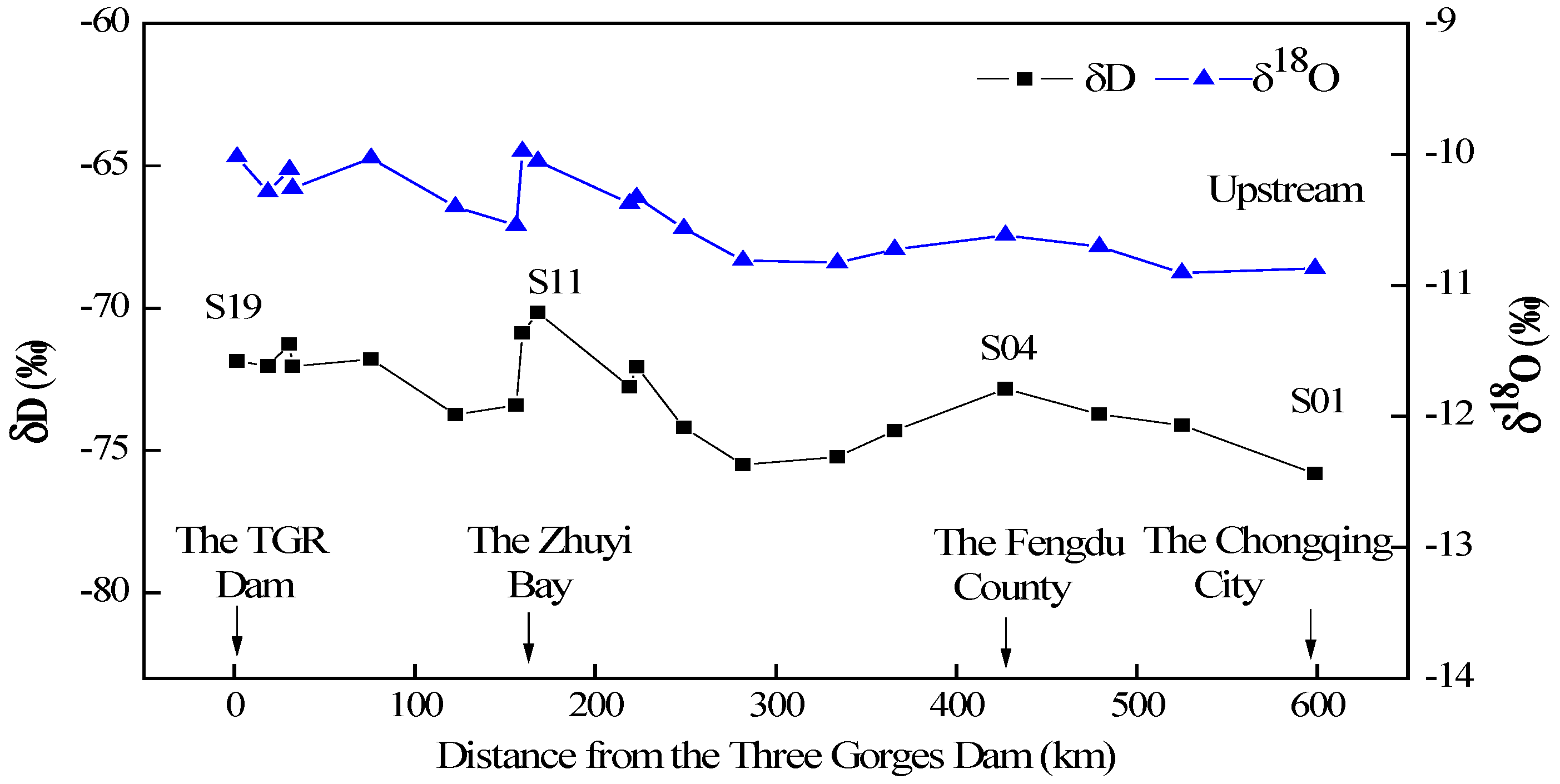
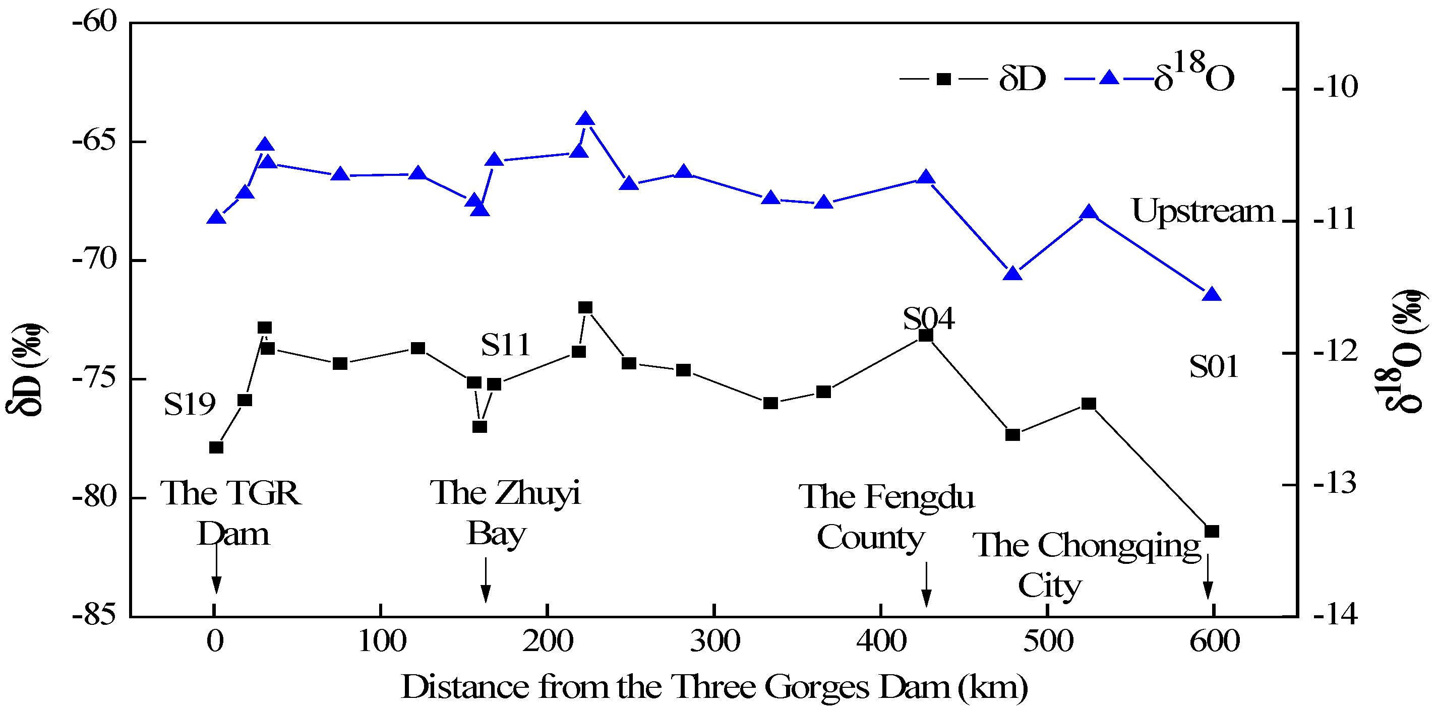
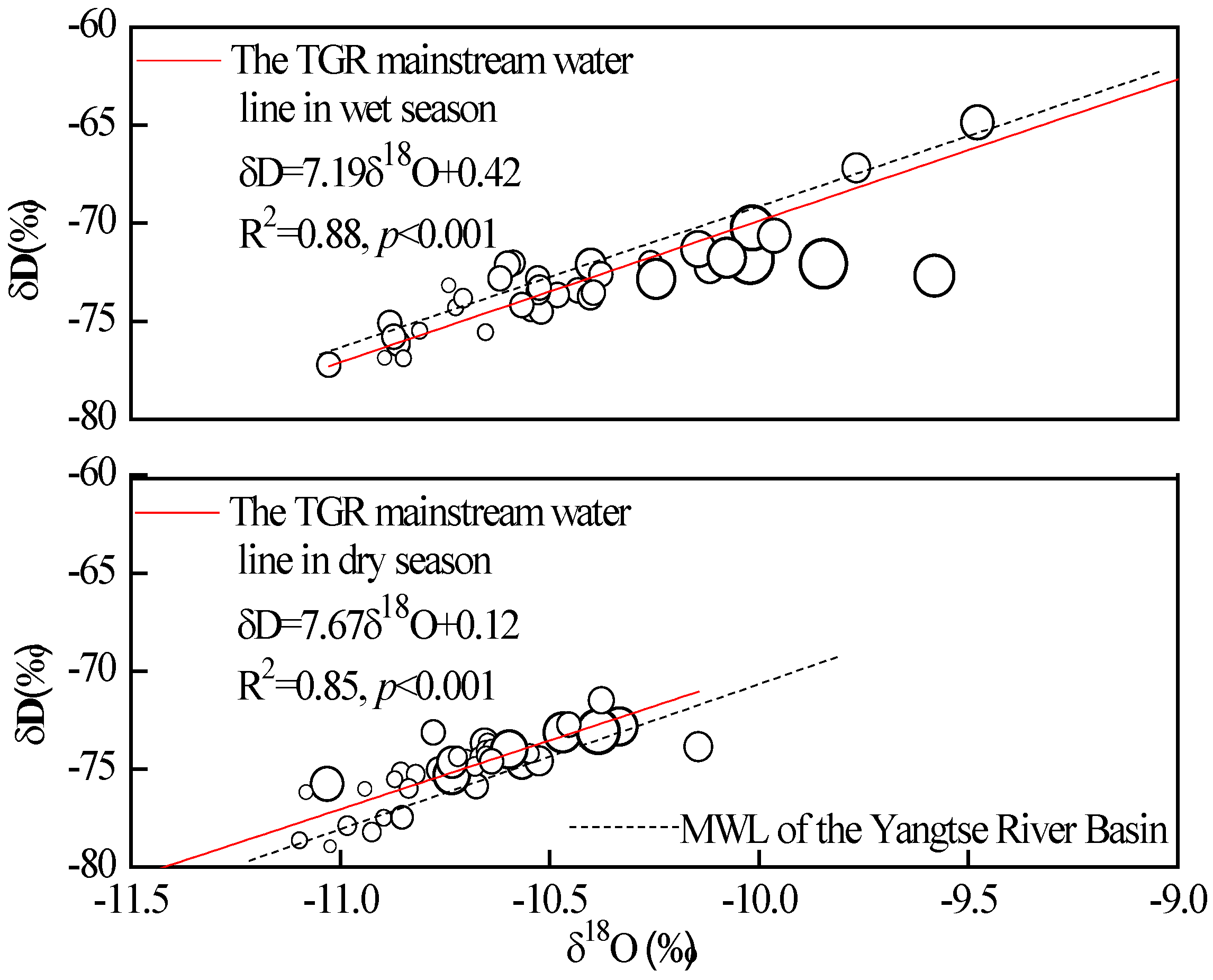
3.1. Spatial and Temporal Variations of δD and δ18O in the TGR Mainstream Water

The spatial and temporal distributions of δD and δ18O in the surface water of TGR mainstream in the wet and dry seasons were shown in Figure 2 and Figure 3, respectively. At the temporal scale, in the wet season, the δ18O ranged from −10.9‰ to −10.0‰ with the mean value of −10.3‰, and the δD varied from −70.1‰ to −75.8‰ with the average of −73.0‰. In the dry season, the isotopic values varied from −11.6‰ to −10.2‰ for δ18O and −81.4‰ to −72.0‰ for δD, with the mean values of −10.7‰ and −75.3‰, which were both slightly more negative than that of the wet season. The one-way ANOVA showed that the mean values of δD (p = 0.001) and δ18O (p = 0.002) were both significantly different between the two seasons, which might be due to the higher degree of evaporation effect in summer and snowmelt water supply in winter.
In Figure 4, the H-O isotopic compositions of the TGR water in wet and dry seasons are presented in linear regressions of δD = 7.19 δ18O + 0.42 and δD = 7.67 δ18O + 0.12, respectively, which were both similar to Meteoric Water Line (MWL) of the Yangtse River Basin (δD = 7.41δ18O + 6.04) [11]. The results indicated that the TGR water, especially in the wet season, was mainly dependent on the supply of precipitation in this basin. In the dry season, the data points above MWL of the Yangtse River basin represented that the snowmelt water might be another water source for the TGR in winter as the snowmelt water had depleted isotope values owing to the fractionation effect during the melting process [20,21,22]. The slope and intercept of the water line in the wet season are slightly less than those of MWL of the Yangtse River Basin, which is caused by the fractionation effect of evaporation.
At the spatial scale, these figures illustrated that the general trend of the water from the downstream was enriched with heavier isotopes (bigger size of point) compared to the water from the upstream, which is similar to that of the Yellow River [23] and Yarlung Zangbo River [24]. At large river basin, altitude is an important factor related to isotopic fractionation for the altitude effect of precipitation. The altitude of the TGR catchment trends to decrease from upstream to downstream. The higher the altitude value, the lower the H-O isotopic value becomes [21,22,23,24]. In addition, the spatial fluctuations of δD and δ18O values of TGR mainstream were related to the nearest tributaries, which should be controlled by different altitudes at which local precipitation occurred [11]. For example, the H-O isotopic values of S13 and S14 were suddenly decreased, which had a close relationship with the water with lower δD and δ18O values (−82.6‰ and −12.7‰, own unpublished data) originated from Wushan Mountain. This phenomenon was also reported in the Heishui Valley, which revealed that the spatial variation of the H-O isotopes from different tributaries was correlated with changes in altitude [22].

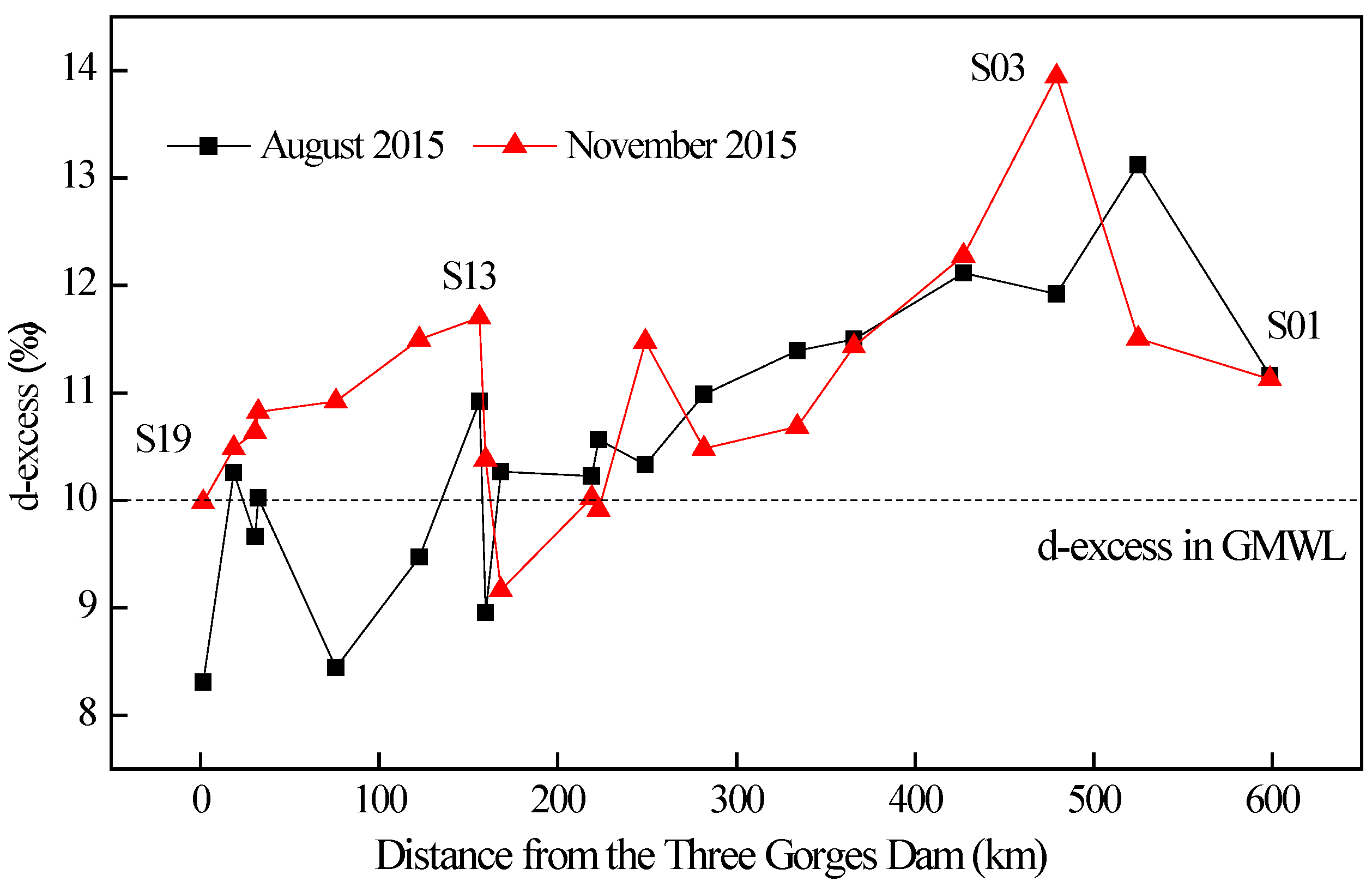
3.2. Spatial and Temporal Variations of D-Excess in the TGR Mainstream Water

Compared to δD and δ18O, the d-excess is a more comprehensive indicator. It reflected the liquid-vapor balance and climate conditions when the precipitation generated [25]. At the temporal scale, the d-excess values in water from the TGR mainstream ranged from 8.3‰ to 13.1‰, with a mean value of 10.5‰ in the wet season, which was lower than the range of 9.1‰ to 13.9‰ with a mean value of 11.2‰ in the dry season (Figure 5). It also showed that the d-excess at different sampling points of the TGR were very similar in different seasons except for three points (S13–S15) between about 75 and 150 km from the TGD and one point (S3) at about 480 km from the TGD. The observed differences in the sampling points of S13 to S15 were probably due to the different inflows conditions of nearest tributaries (Caotang River and Shenlong River) originating from Wushan Mountain and Shenlong Mountain [11]. The seasonal variation for S3 might be caused by the evaporation effect in summer.
At the spatial scale, this general trend of increasing d-excess with increasing distance from the TGD during the wet and dry seasons indicated that the kinetic fractionation effect caused by evaporation was a significant process for the H-O isotopic composition of the TGR, especially in the downstream, where a higher degree of evaporation usually occurred. This phenomenon is a common observation for large river systems. Zhou et al. [11] found that obvious enrichment evaporation effect of H-O isotopes took place at the downstream of Yangtse River. This pattern is also similar to that observed in the Yamzho Yumco Lake, which showed that the lake water flowed from the river entrance to the middle part of the lake, which was ultimately evaporated there (with higher δD and δ18O values) [26].
Above all, we concluded that precipitation was the main source of the TGR water. The spatial and temporal variabilities of H-O isotopes were mainly influenced by the isotopic composition of incoming water from tributaries, which was controlled by the altitude effect and continuous evaporation effect along the runoff direction and a higher degree of evaporation effect in the wet season.

3.3. Interaction Process at the Confluence Zone of the TGR Mainstream and Its Tributary—A Case Study of the Zhuyi Bay

With the operation of the TGR, the water levels fluctuate constantly and the water exchanges frequently. The stratified density currents within the confluence zone between the mainstream and its tributaries vary between seasons, which will determine the different supply models and distribution patterns of nutrients in tributaries. Therefore, it is important to analyze the dynamic characteristics within the confluence area, as well as to further reveal the causes of eutrophication in the tributaries.

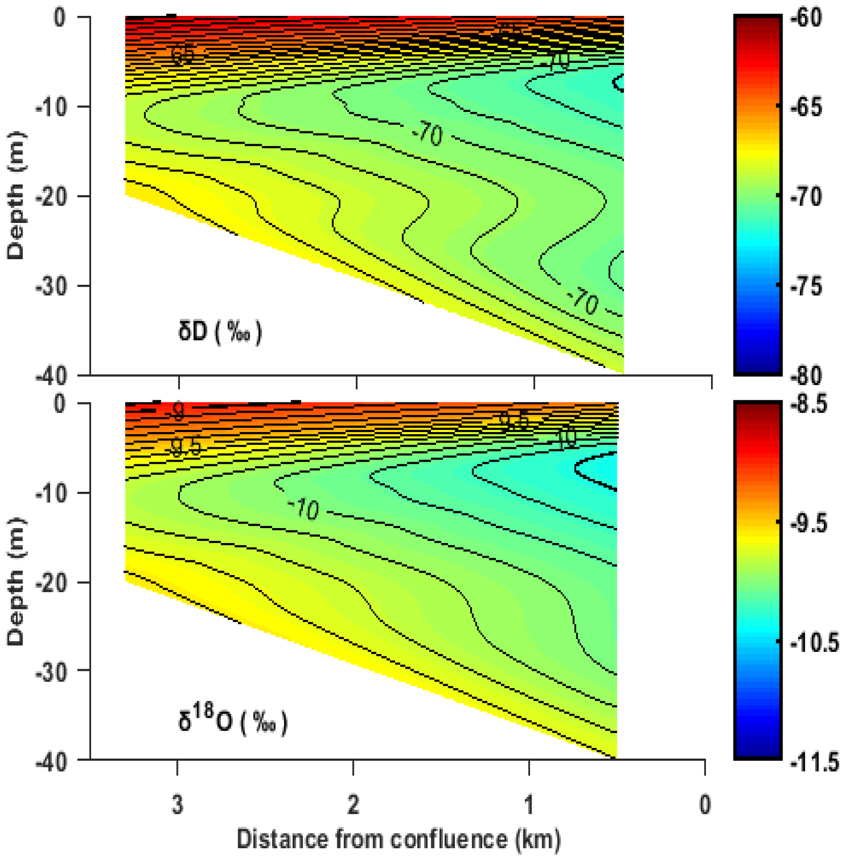
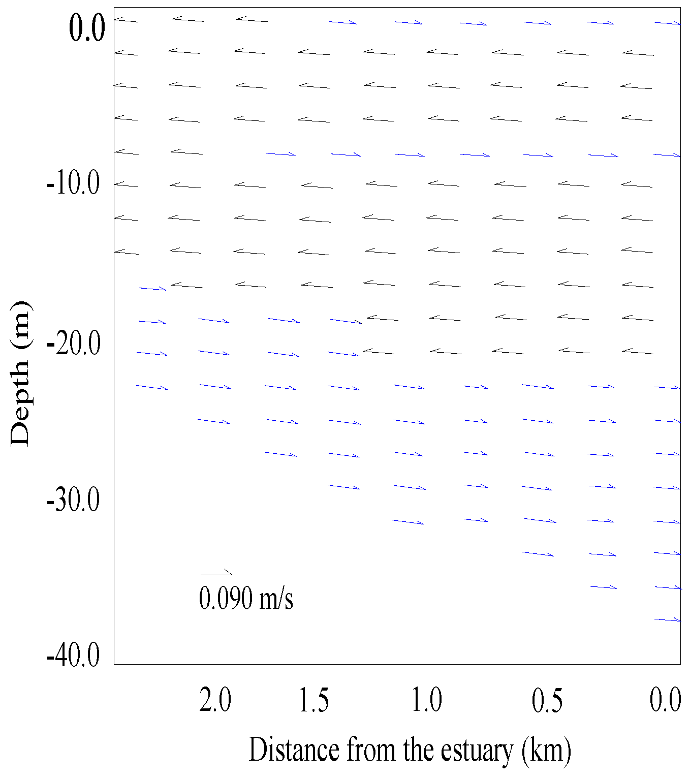
3.3.1. The Wet Season (August 2015)

In the wet season, the water level of the TGR fluctuated between 145 m and 150 m, the water depth of the ZYB was reduced from 60 m to 40 m and its length was shortened to 3 km due to the scheduling model of the TGR. The δD and δ18O values of the TGR mainstream (S11) were (−71.2 ± 0.7) ‰ and (−10.1 ± 0.1) ‰. The δD and δ18O values of the water source of the ZYB (ZY04) were (−48.6 ± 1.1) ‰ and (−7.5 ± 0.1) ‰. Significant differences in δD and δ18O values (p < 0.01) between the TGR stream and the water source of the ZYB were found. Hence, both δD and δ18O values could be used as water mass indicators in the confluence zone.
The δD and δ18O values of the confluence zone in the ZYB (ZY01-ZY03) ranged from −71.3‰ to −63.9‰ and from −10.3‰ to −8.9‰ with obvious stratification (Figure 6). In horizontal orientation, a wedge-shaped gradient region appeared at the estuary and extended to the upstream. The δD and δ18O values increased from the estuary to the upstream accordingly. In the vertical direction, the δD and δ18O values decreased to the minimum at a depth of 10 m and then increased gradually. It illustrated that the water from the TGR mainstream was introduced via the upper-middle layers into the ZYB water column, whereas the water from the upstream of the ZYB flowed to the mainstream from the bottom layers in the wet season. The phenomenon was also found in other tributaries of the TGR, like in Xiangxi Bay [18].
The vertical temporal distributions of flow velocity in the sampling site (ZY01) in the wet season were depicted in Figure 7. The average values of the normal (flowing to the TGR mainstream) and the reverse flow velocities (flowing up the ZYB) were 0.087 and −0.091m/s, respectively. It was shown that there was a wedge appearing from the estuary (from 2 m to 20 m underwater) to upstream (from the surface to 16 m underwater) (the black arrows), which means that water of the mainstream of the TGR imported into the ZYB from the upper-middle layers, while the water of ZYB exported into the main channel of the TGR from the bottom layers (the white arrows), which is in accordance with the results of the H-O isotopes tracing results.

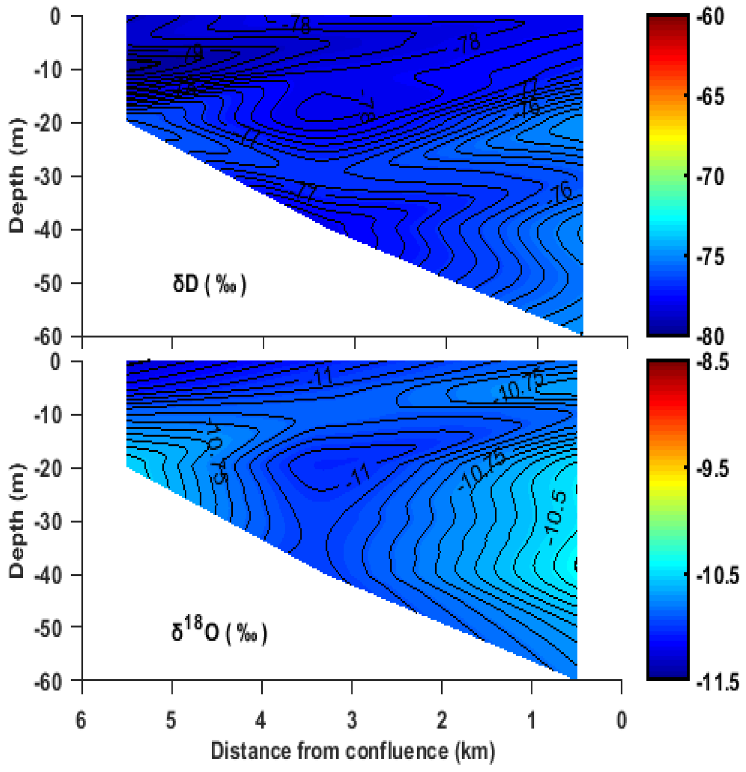
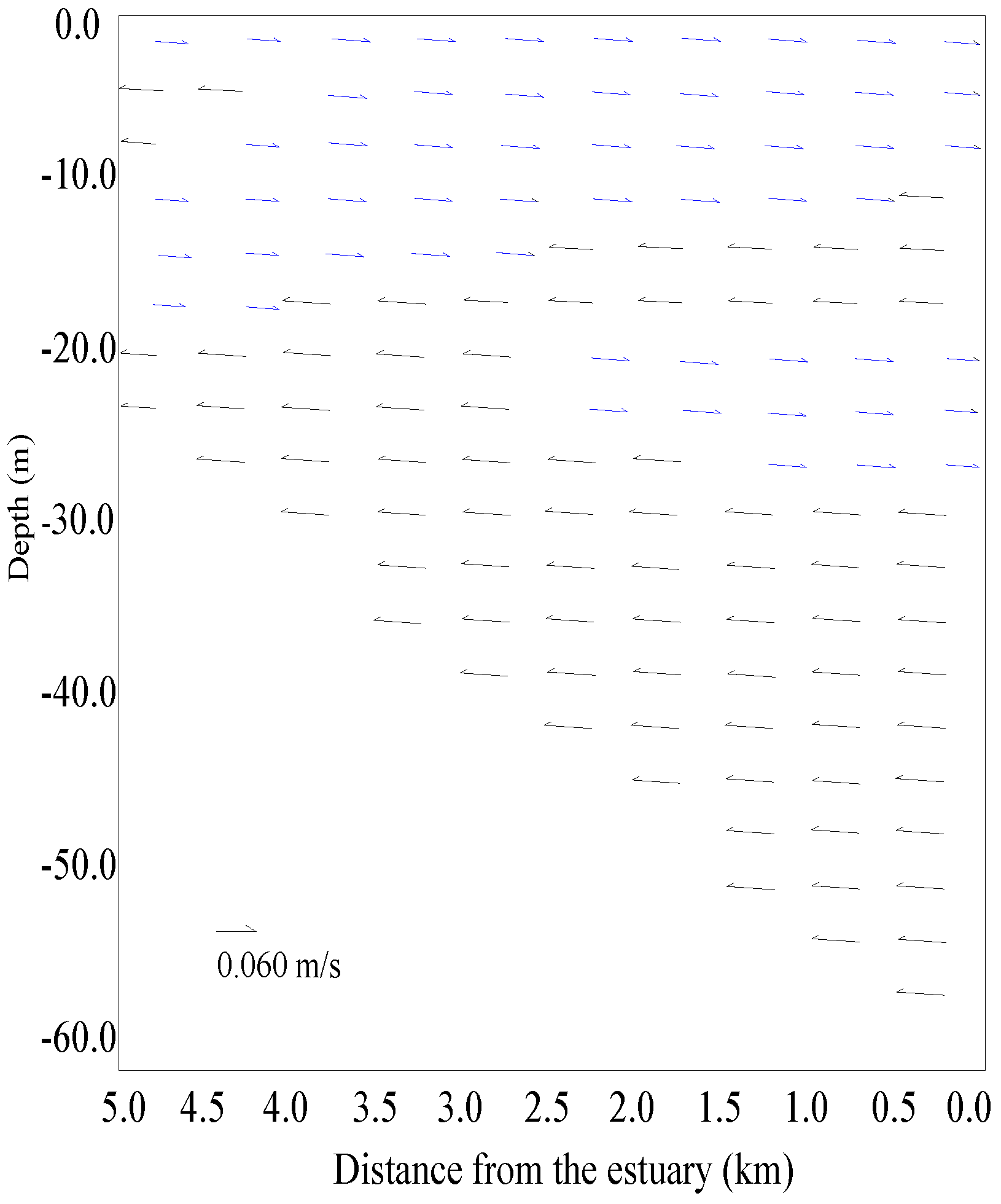
3.3.2. The Dry Season (November 2015)

In the dry season, since the impoundment of the TGR, the water level of the TGR fluctuated between 170 m and 175 m. A remarkable decrease in the average values of 0.057 m/s and −0.063 m/s of the normal, and reverse flow velocities in the confluence zone of ZYB occurred. The water mass of the TGR mainstream flowed backward to the ZYB, increasing the water depth to 60 m and extending the river length to 5 km. The δD and δ18O values of the TGR main channel were (–76.3 ± 0.9) ‰ and (−10.5 ± 0.1) ‰, which were significant differences (p < 0.01) of the δD values (−48.1 ± 1.8) ‰and δ18O values (−7.4 ± 0.2) ‰in the water source of ZYB.
In the confluence zone (ZY01–ZY03), the δD and δ18O values ranged from −78.6‰ to −73.7‰ and from −11.1‰ to −10.0‰, respectively. From Figure 8, it could be seen that the interaction process in the confluence zone tremendously changed compared with that in the wet season. The water from the TGR mainstream generally flowed backward into the ZYB through the middle and bottom layers. However, the water from the upstream of ZYB exported into the TGR mainstream from the middle and upper layers. The results were consistent with the flow velocity expressed in Figure 9.
The dynamic characteristics of the TGR are influenced by certain driving factors such as the thermal density flow, the water level fluctuation and so on [27,28,29]. In the dry season, there is no significant difference in the temperature between the mainstream and ZYB water. The water of the main channel would import into ZYB through the middle and bottle layers with smaller intrusion ranges. In the wet season, the temperature of surface water in ZYB rapidly warms up while the middle and bottom water remain under a relatively low temperature state. However, the mainstream water of the TGR is mixed more evenly without clear thermal stratification due to its high flow rate and velocity. On 26 August 2015, the temperature of the TGR mainstream (M11) was 25.3 °C which was between that of the surface water (27.5 °C) and bottom water (24.9 °C) of ZYB. As water temperature will change water density, the mainstream water with higher density would flow backward to the surface layer of ZYB (lower density), whereas the water of ZYB would export into the TGR mainstream through the bottom layer.
It has been reported that a large quantity of the water from the TGR mainstream with higher nutrients flowed back to the surface and middle portions of tributaries due to the density of the currents during the wet season [6]. The stratification phenomenon hampered the exchanges of water bodies in different depths and helped to accumulate algae to form algal blooms within the surface water. Therefore, we think, it is also possible to control the degree of eutrophication of the tributaries to a certain extent if the stratified density current can be controlled by changing the flow characteristics through some measures such as reservoir scheduling.

4. Conclusions

The study presented water H-O isotopic compositions in the mainstream and a tributary (Zhuyi Bay) of the TGR in 2015 and showed that the H-O isotopes and d-excess can be used to indicate the water cycle of the reservoir and reveal the stratification phenomenon that occurred in the confluence zone between the mainstream and tributary. Isotopic analysis showed that linear regressions of the TGR were δD = 7.19δ18O + 0.42 and δD = 7.67δ18O + 0.12 in the wet and dry seasons, respectively and suggested that precipitation was the major source of water for the TGR ultimately.
The fluctuations of δD and δ18O values along the runoff direction of TGR mainstream displayed a spatial difference, showing that the water from the downstream was generally enriched with heavier isotopes, which primarily resulted from the continuous evaporation effect along the runoff direction and different water supplies from nearest tributaries. Meanwhile, the spatial distributions of d-excess decreased from upstream to downstream, which indicated that kinetic fractionation effect was an important process in the TGR.
The observation of water H-O isotopes in ZYB showed that the water mass from the TGR mainstream flowed backward to the confluence zone via the upper-middle layers in the wet season. However, in the dry season, the water reversed through the middle and bottom layers with smaller intrusion ranges. These findings matched well with the results of flow velocities. This stratification phenomenon might hamper the exchanges of water bodies in the tributaries and help to accumulate algae to form algal blooms within the surface water, which requires further research.

Supplementary Materials

The following are available online at https://www.mdpi.com/2073-4441/10/5/563/s1. Table S1: The information of the water samples in the mainstream and Zhuyi Bay.

Author Contributions

Y.B., Y.S. and Y.W. conceived and designed the experiments; Y.B., R.J., A.C., P.D., and Z.Y. performed the experiments; Y.W., Y.C., Y.B. and M.H. analyzed the data; Y.B. and R.J. wrote the paper. All authors reviewed the manuscript.

Funding

This research was funded by the National Key Research and Development Program (No. 2017YFC0404703), the Major Science and Technology Program for Water Pollution Control and Treatment in China (No. 2017ZX07301006005), the National Natural Science Foundation of China (No. 91647208, No. 51679258, No. 91547109 and No. 51509066), the environmental protection project of China Three Gorges Corporation (0799562) and the Open Research Fund of State Key Laboratory of Simulation and Regulation of Water Cycle in River Basin, China Institute of Water Resources and Hydropower Research (SKL2016ZY04, SKL2018ZY04).

Acknowledgments

A special thank goes to Jianqun Zhang and Linxuan Lu from Beijing Jiaotong University who reviewed the English of the paper and gave invaluable support for Yufei Bao.

Conflicts of Interest

The authors declare no conflict of interest.

References

  1. Chen, H.; Wu, Y.; Yuan, X.; Gao, Y.; Wu, N.; Zhu, D. Methane emissions from newly created marshes in the drawdown area of the three gorges reservoir. J. Geophys. Res. Atmos. 2009, 114, D18301. [Google Scholar] [CrossRef]
  2. Wu, Y.; Wang, X.; Zhou, J.; Bing, H.; Sun, H.; Wang, J. The fate of phosphorus in sediments after the full operation of the Three Gorges Reservoir, China. Environ. Pollut. 2016, 214, 282–289. [Google Scholar] [CrossRef] [PubMed]
  3. López, P.; Lópeztarazón, J.A.; Casasruiz, J.P.; Pompeo, M.; Ordoñez, J.; Muñoz, I. Sediment size distribution and composition in a reservoir affected by severe water level fluctuations. Sci. Total Environ. 2016, 540, 158–167. [Google Scholar] [CrossRef] [PubMed]
  4. Ye, Z.; Wang, Y.; Hu, M.; Wang, G.; Liang, S.; Wang, Q.; Gao, J.; Liu, D. Hydrogen and oxygen stable isotope tracing of eco-hydrological processes in water bodies mixing the mainstream and a tributary of the Three Gorges Reservoir. Chin. J. Ecol. 2017, 36, 2358–2366. [Google Scholar]
  5. Zhao, Y.; Zheng, B.; Wang, L.; Qin, Y.; Li, H.; Cao, W. Characterization of mixing processes in the confluence zone between the Three Gorges Reservoir mainstream and the Daning river using stable isotope analysis. Environ. Sci. Technol. 2016, 50, 9907–9914. [Google Scholar] [CrossRef] [PubMed]
  6. Liu, L.; Liu, D.; Johnson, D.M.; Yi, Z.; Huang, Y. Effects of vertical mixing on phytoplankton blooms in Xiangxi bay of Three Gorges Reservoir: implications for management. Water Res. 2012, 46, 2121–2130. [Google Scholar] [CrossRef] [PubMed]
  7. Cao, L.; Zhang, Y.; Shi, Y. Climate change effect on hydrological processes over the Yangtze River basin. Quat. Int. 2011, 244, 202–210. [Google Scholar] [CrossRef]
  8. Wang, X.; Qiao, W.; Chen, J.; Liu, X.; Yang, F. Understanding the burial and migration characteristics of deep geothermal water using hydrogen, oxygen, and inorganic carbon isotopes. Water 2018, 10, 7. [Google Scholar] [CrossRef]
  9. Maruyama, S.; Kato, H. Identification of waters incorporated in Laguna Lake, republic of the philippines, based on oxygen and hydrogen isotopic ratios. Water 2017, 9, 328. [Google Scholar] [CrossRef]
  10. Li, Y.; Yao, J.; Zhang, L. Investigation into mixing in the shallow floodplain Poyang Lake (China) using hydrological, thermal and isotopic evidence. Water Sci. Technol. 2016, 74, 2582–2598. [Google Scholar] [CrossRef] [PubMed]
  11. Zhou, Y.; Wu, H.; He, B.; Li, J.; Duan, W.; Wang, J.; Tong, S. Study on spatial and temporal variations of δ18O and δD in Yangtze River water and its factors. Resour. Environ. Yangtze Basin 2017, 26, 678–686. [Google Scholar]
  12. Jasechko, S.; Gibson, J.J.; Edwards, T.W.D. Stable isotope mass balance of the Laurentian Great Lakes. J. Great Lakes Res. 2014, 40, 336–346. [Google Scholar] [CrossRef]
  13. Xiao, W.; Fu, J.; Wang, W.; Wen, X.; Xu, J.; Xiao, Q.; Hu, C.; Liu, S.; Li, X. Estimating evaporation over a large and shallow lake using stable isotopic method: A case study of Lake Taihu. J. Lake Sci. 2017, 29, 1009–1017. [Google Scholar]
  14. Mortatti, J.; Moraes, J.M.; Rodrigues, J.C., Jr.; Victoria, R.L.; Martinelli, L.A. Hydrograph separation of the amazon river using 18O as an isotopic tracer. Sci. Agric. 1997, 54, 278–286. [Google Scholar] [CrossRef]
  15. Zhang, J.; Letolle, R.; Martin, J.M.; Jusserand, C.; Mouchel, J.M. Stable oxygen isotope distribution in the Huanghe (Yellow River) and the Changjiang (Yangtze River) estuarine systems. Cont. Shelf Res. 1990, 10, 369–384. [Google Scholar] [CrossRef]
  16. Li, C.; Yang, S.; Lian, E.; Yang, C.; Deng, K.; Liu, Z. Damming effect on the Changjiang (Yangtze River) river water cycle based on stable hydrogen and oxygen isotopic records. J. Geochem. Explor. 2016, 165, 125–133. [Google Scholar] [CrossRef]
  17. Deng, K.; Yang, S.; Lian, E.; Li, C.; Yang, C.; Wei, H. Three gorges dam alters the Changjiang (Yangtze) river water cycle in the dry seasons: evidence from H-O isotopes. Sci. Total Environ. 2016, 562, 89–97. [Google Scholar] [CrossRef] [PubMed]
  18. Yang, L.; Liu, D.; Huang, Y.; Yang, Z.; Ji, D.; Song, L. Isotope analysis of the nutrient supply in Xiangxi Bay of the Three Gorges Reservoir. Ecol. Eng. 2015, 77, 65–73. [Google Scholar] [CrossRef]
  19. Dansgaard, W. Stable isotopes in precipitation. Tellus 1964, 16, 436–468. [Google Scholar] [CrossRef]
  20. Wang, Y.; Chen, Y.; Li, W. Temporal and spatial variation of water stable isotopes (18O and 2H) in the Kaidu River basin, northwestern China. Hydrol. Process. 2014, 28, 653–661. [Google Scholar] [CrossRef]
  21. Liu, Y.; An, S.; Xu, Z.; Fan, N.; Cui, J.; Wang, Z.; Liu, S.; Pan, J.; Lin, G. Spatio-temporal variation of stable isotopes of river waters, water source identification and water security in the Heishui Valley (China) during the dry-season. Hydrogeol. J. 2008, 16, 311–319. [Google Scholar] [CrossRef]
  22. Liu, Y.; Fan, N.; An, S.; Bai, X.; Liu, F.; Xu, Z.; Wang, Z.; Liu, S. Characteristics of water isotopes and hydrograph separation during the wet season in the Heishui River, China. J. Hydrol. 2008, 353, 314–321. [Google Scholar] [CrossRef]
  23. Li, S.L.; Yue, F.J.; Liu, C.Q.; Ding, H.; Zhao, Z.Q.; Li, X. The O and H isotope characteristics of water from major rivers in China. Chin. J. Geochem. 2015, 34, 28–37. [Google Scholar] [CrossRef]
  24. Gao, Z.; Wang, X.; Guan, Y. Hydrological rule and isotopic composition of water bodies in Yarlung Zangbo River. Acta Geol. Sin. 2007, 62, 1002–1007. [Google Scholar]
  25. Jouzel, J.; Stiévenard, M.; Johnsen, S.J.; Landais, A.; Masson-Delmotte, V.; Sveinbjornsdottir, A.; Vimeux, F.; Grafenstein, U.; White, J.W.C. The grip deuterium-excess record. Quat. Sci. Rev. 2007, 26, 1–17. [Google Scholar] [CrossRef]
  26. Zang, Y.; Wang, J.; Tian, L.; Weng, Y.; Wen, R.; Zong, J. The spatial distribution of stable isotopes in Yamzhoyumco Lake. J. Southwest Univ. (Nat. Sci. Ed.) 2014, 36, 1–6. [Google Scholar]
  27. Bao, Y.; Wang, Y.; Hu, M.; Wang, Q. Phosphorus fractions and its summer flux from sediments of deep reservoirs located at a phosphate-rock watershed, Central China. Water Sci. Technol. Water Supply 2018, 18, 688–697. [Google Scholar] [CrossRef]
  28. Huang, Y.; Zhang, P.; Liu, D.; Yang, Z.; Ji, D. Nutrient spatial pattern of the upstream, mainstream and tributaries of the Three Gorges Reservoir in China. Environ. Monit. Assess. 2014, 186, 6833–6847. [Google Scholar] [CrossRef] [PubMed]
  29. Ji, D.; Wells, S.A.; Yang, Z.; Liu, D.; Huang, Y.; Ma, J.; Berger, C.J. Impacts of water level rise on algal bloom prevention in the tributary of Three Gorges Reservoir, China. Ecol. Eng. 2017, 98, 70–81. [Google Scholar] [CrossRef]
Figure 1. Sampling sites of the Three Gorges Reservoir mainstream and Zhuyi Bay.
Water 10 00563 g001
Figure 2. Spatial variation of the δD and δ18O stable isotopes along the TGR mainstream during the wet season (August 2015).
Water 10 00563 g002
Figure 3. Spatial variation of the δD and δ18O stable isotopes along the TGR mainstream during the dry season (November 2015).
Water 10 00563 g003
Figure 4. Correlations between δD and δ18O of the TGR in the wet and dry seasons (n = 114). MWL of the Yangtse River Basin: Meteoric Water Line of the Yangtse River Basin [11]. The bigger the size of point’s figure is, the closer the sampling point is to the TGD.
Water 10 00563 g004
Figure 5. The fluctuations of d-excess in the TGR mainstream water during the dry and wet seasons. GMWL: Global Meteoric Water Line [18].
Water 10 00563 g005
Figure 6. Spatial variation of the δD and δ18O in the Zhuyi Bay in the wet season.
Water 10 00563 g006
Figure 7. Vertical distribution of flow velocity in the Zhuyi Bay during the wet season. Note: The blue arrows represent the water flows from the Zhuyi Bay into the mainstream of the TGR (normal flow velocities), while the black arrows indicate the reverse flow (reverse flow velocities).
Water 10 00563 g007
Figure 8. Spatial variation of the δD and δ18O in the Zhuyi Bay during the dry season.
Water 10 00563 g008
Figure 9. Vertical distribution of flow velocity in the Zhuyi Bay in the dry season. Note: The blue arrows represent the water flows from the Zhuyi Bay into mainstream of the TGR (normal flow velocities), while, the black arrows indicate the reverse flow (reverse flow velocities).
Water 10 00563 g009

