Article

Sustainability Evaluation Framework of Urban Stormwater Drainage Options for Arid Environments Using Hydraulic Modeling and Multicriteria Decision-Making

by
Mohammad Alhumaid
1,
Abul Razzaq Ghumman
2,*,
Husnain Haider
2,
Ibrahim Saleh Al-Salamah
2 and
Yousry Mahmoud Ghazaw
2,3
1
Municipality of Buraydah, Buraydah, 51431 Al Qassim, Saudi Arabia
2
Department of Civil Engineering, College of Engineering, Qassim University, Buraydah, 51431 Al Qassim, Saudi Arabia
3
Department of Irrigation and Hydraulics, College of Engineering, Alexandria University, Alexandria 21544, Egypt
*
Author to whom correspondence should be addressed.
Water 2018, 10(5), 581; https://doi.org/10.3390/w10050581
Submission received: 24 March 2018 / Revised: 10 April 2018 / Accepted: 23 April 2018 / Published: 29 April 2018
(This article belongs to the Section Urban Water Management)

Abstract

:
Stormwater drainage systems in urban areas located in arid environmental regions generally consist of storm-sewer networks and man-made ponds for the collection and disposal of runoff, respectively. Due to expansion in cities’ boundaries as a result of population growth, the capacity of existing drainage systems has been exhausted. Therefore, such systems overflow even during the smaller (than the design) return period floods. At the same time, changing rainfall patterns and flash floods due to climate change are other phenomena that need appropriate attention. Consequently, the municipalities in arid environmental regions are facing challenges for effective decision-making concerning (i) improvement needs for drainage networks for safe collection of stormwater, (ii) selection of most feasible locations for additional ponds, and (iii) evaluation of other suitable options, such as micro-tunneling. In this research, a framework has been developed to evaluate different stormwater drainage options for urban areas of arid regions. Rainfall-runoff modeling was performed with the help of Hydrological-Engineering-Centre, Hydrological-Modelling-System (HEC-HMS). To evaluate the efficacy of each option for handling a given design flood, hydraulic-modeling was performed using SewerGEMS. Meteorological and topographical data was gathered from the Municipality of Buraydah and processed to generate different inputs required for hydraulic modeling. Finally, multicriteria decision-making (MCDM) was performed to evaluate all the options on the basis of four sustainability criteria, i.e., flood risk, economic viability, environmental impacts, and technical constraints. Criteria weights were established through group decision-making using the Analytic Hierarchy Process (AHP). Preference-Ranking-Organization-Method for Enrichment-Evaluation (PROMETHEE II) was used for final ranking of stormwater drainage options. The proposed framework has been implemented on a case of Buraydah City, Qassim, Saudi Arabia, to evaluate its pragmatism. Micro-tunnelling was found to be the most sustainable option.

1. Introduction

Stormwater management in urban areas has been recognized as a serious challenge around the world [1,2,3]. Increasing impervious areas as a result of urbanization is continually increasing the risk of flash floods [4,5,
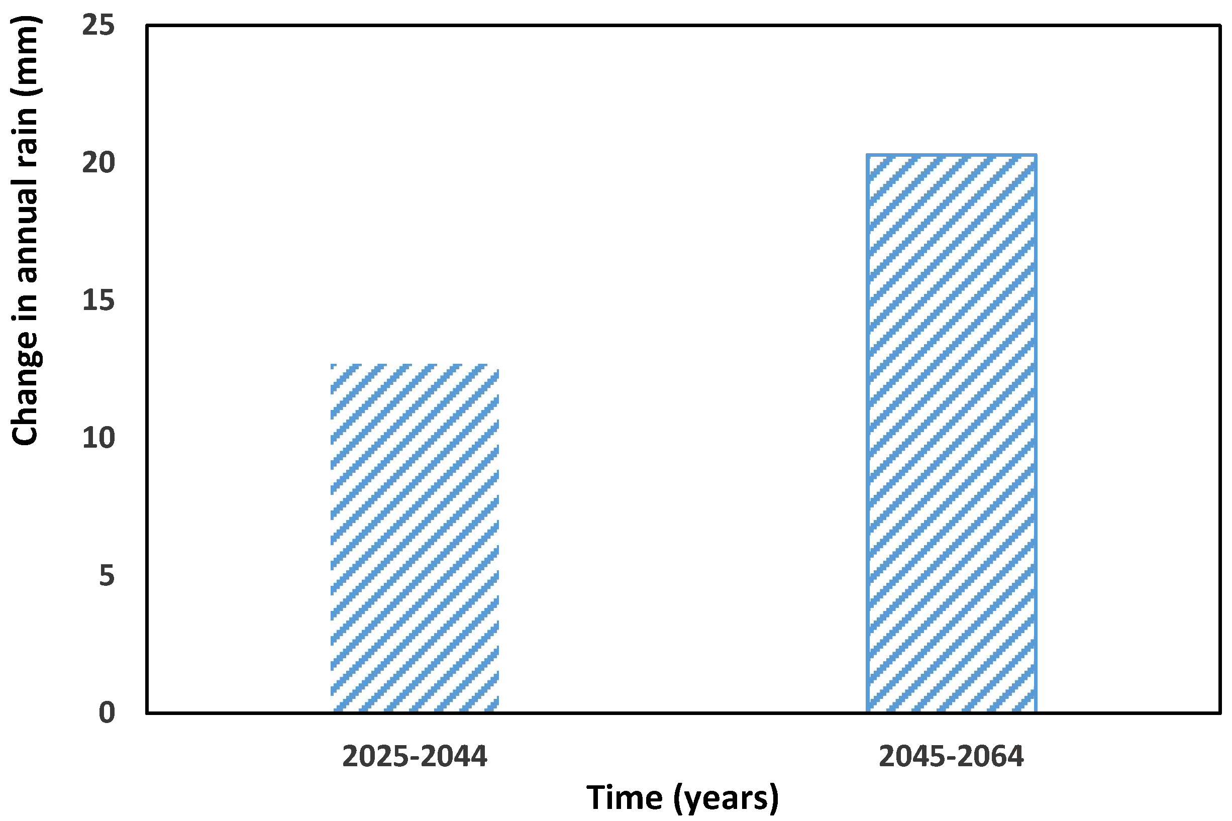
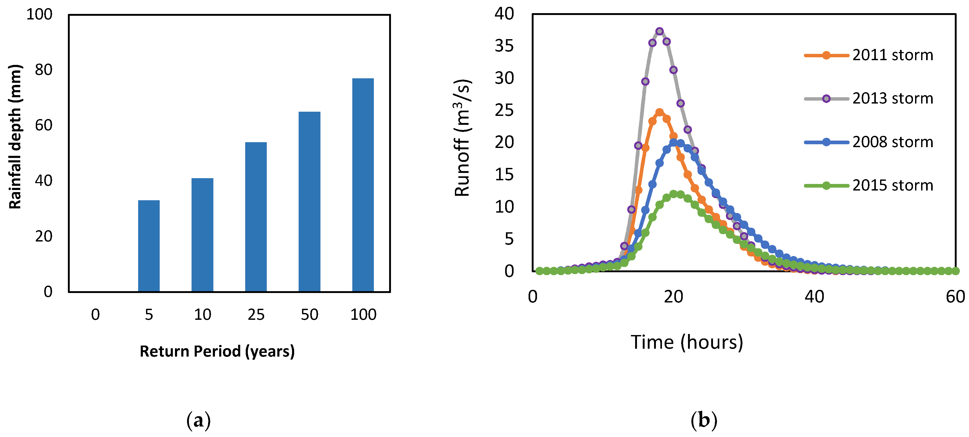
6]. Due to occasional rainfall in semi-arid to arid environmental regions, proper consideration has not been given to stormwater management. In the recent past, climate change and environmental impacts, as a result of industrialization, have changed the predicted patterns and intensities of rainfall events in various regions (Figure 1) [7]. Therefore, this impact should be considered in the management of existing stormwater drainage infrastructure for safe collection and disposal of runoff. The problem becomes more significant in locations where natural wadies, which safely route the storm water, have been blocked by the expansion of cities and urbanization in arid regions [8,9].
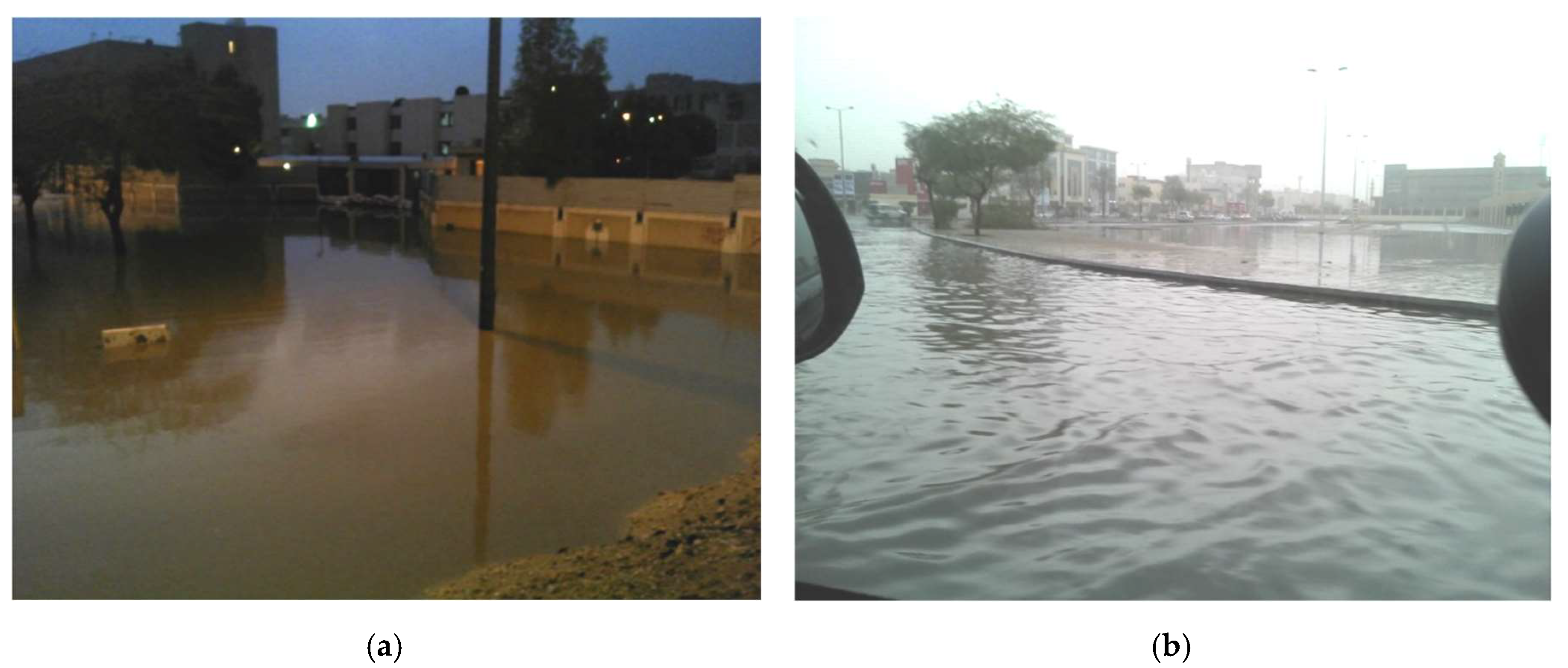
In the Gulf region, the natural drainage patterns have been significantly altered due to urbanization. This problem is more significant in cities having rolling (presence of small hills) terrain where natural topographical constraints avert the runoff to be disposed-off to a nearby Wadi [
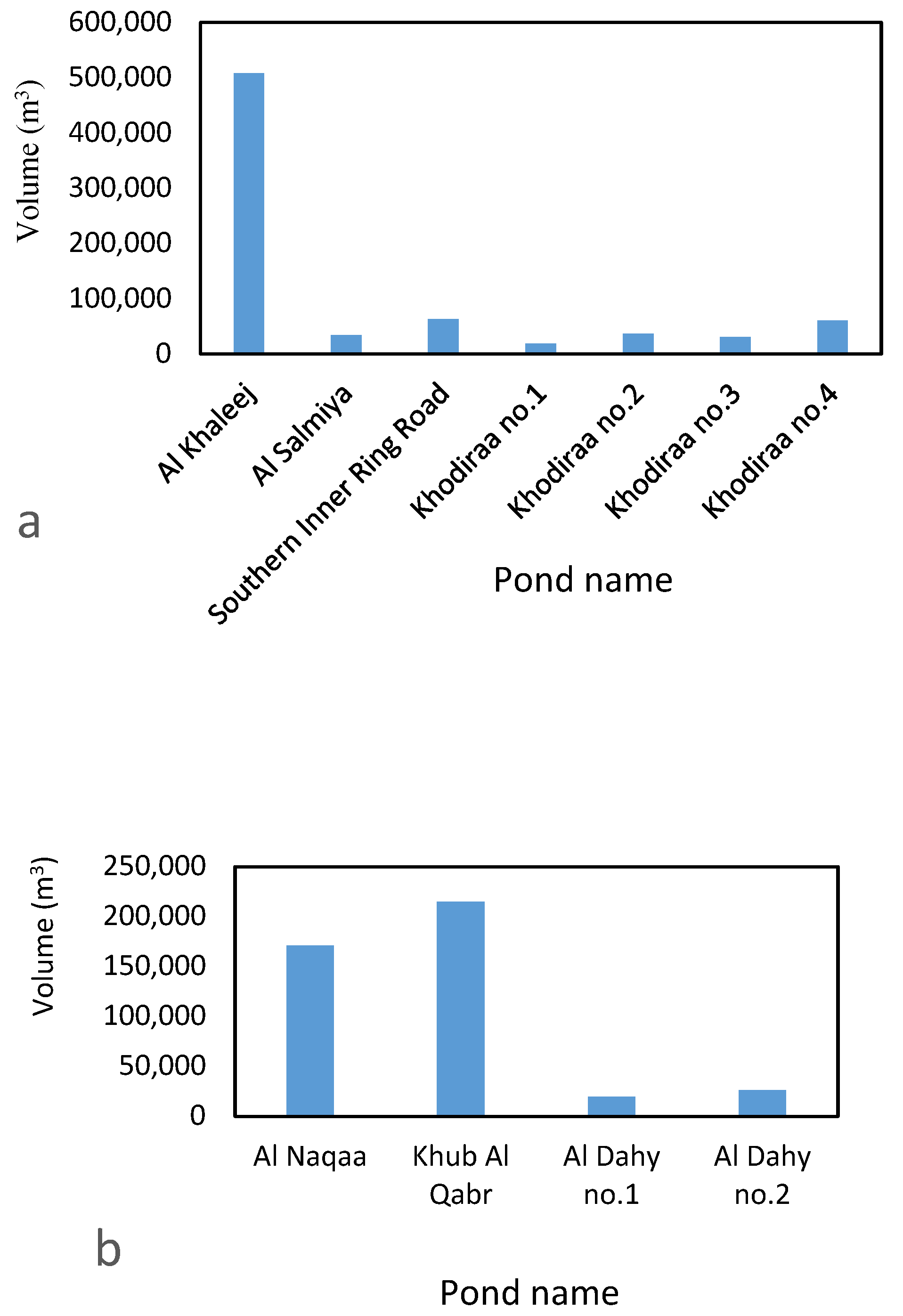
10]. As a result, surface ponds located within the city’s boundaries are being used as a final disposal point for stormwater. The problem has significantly been increased with expansion of cities, as a result of population growth, when the existing drainage systems overflow even during the smaller (than the design) return period floods. Presently, the municipality managers in arid environmental regions, are looking for answers of some critical questions for effective decision-making, such as (i) how much capacity of the existing storm-sewer infrastructure needs to be enhanced for a given return period flood, (ii) how to select the most feasible locations of additional ponds for safe disposal of the increased stormwater due to urbanization, and (iii) how to evaluate the technical, economic, and environmental sustainability of various stormwater drainage options. Therefore, there is a dire need to develop a framework that can answer these questions to facilitate the municipality mangers for effective decision-making.
In the past, various studies have been conducted on flood risk management for arid and humid regions. Chen et al. [1] introduced simplified urban inundation simulation using storm water management model for a city in China. Thomas [11] developed different coefficients to find storm water from urban areas in Sweeden. Ali et al. [9] conducted a detailed review of literature on various aspects of flood risk. Al-Zahrani et al. [12] developed a flood inundation and hazard map for flood management using Hydrological-Engineering-Centre, Hydrological-Modelling-System (HEC-HMS) in the Kingdom of Saudi Arabia (KSA). Almalki [10] conducted interviews with people and municipality staff to highlight the technical and cost-related issues for flood management in KSA.
Some studies discussed general aspects of flood management in KSA [13,14,15]. However, in-depth analysis addressing the impacts of urbanization and climate change on existing and improved (to handle longer return period floods) storm water drainage infrastructure in KSA have rarely been reported. In general, the storm sewer networks in arid regions were designed for shorter return period storms; consequently, storm water accumulates in streets during high return period floods and poses risk to life and property [15,16]. Floods of more than 20 years return period have been observed in Saudi Arabia in the recent past [17]. This precious stormwater as a result of high return period floods also needs to be conserved for beneficial uses. Hence, the detailed design of the whole storm sewer network needs to be re-visited, using state-of-the-art methods, which has not been taken care of in the past studies. Finally, different management options may have varying technical, environmental, and financial considerations that should be evaluated in the decision-making process.
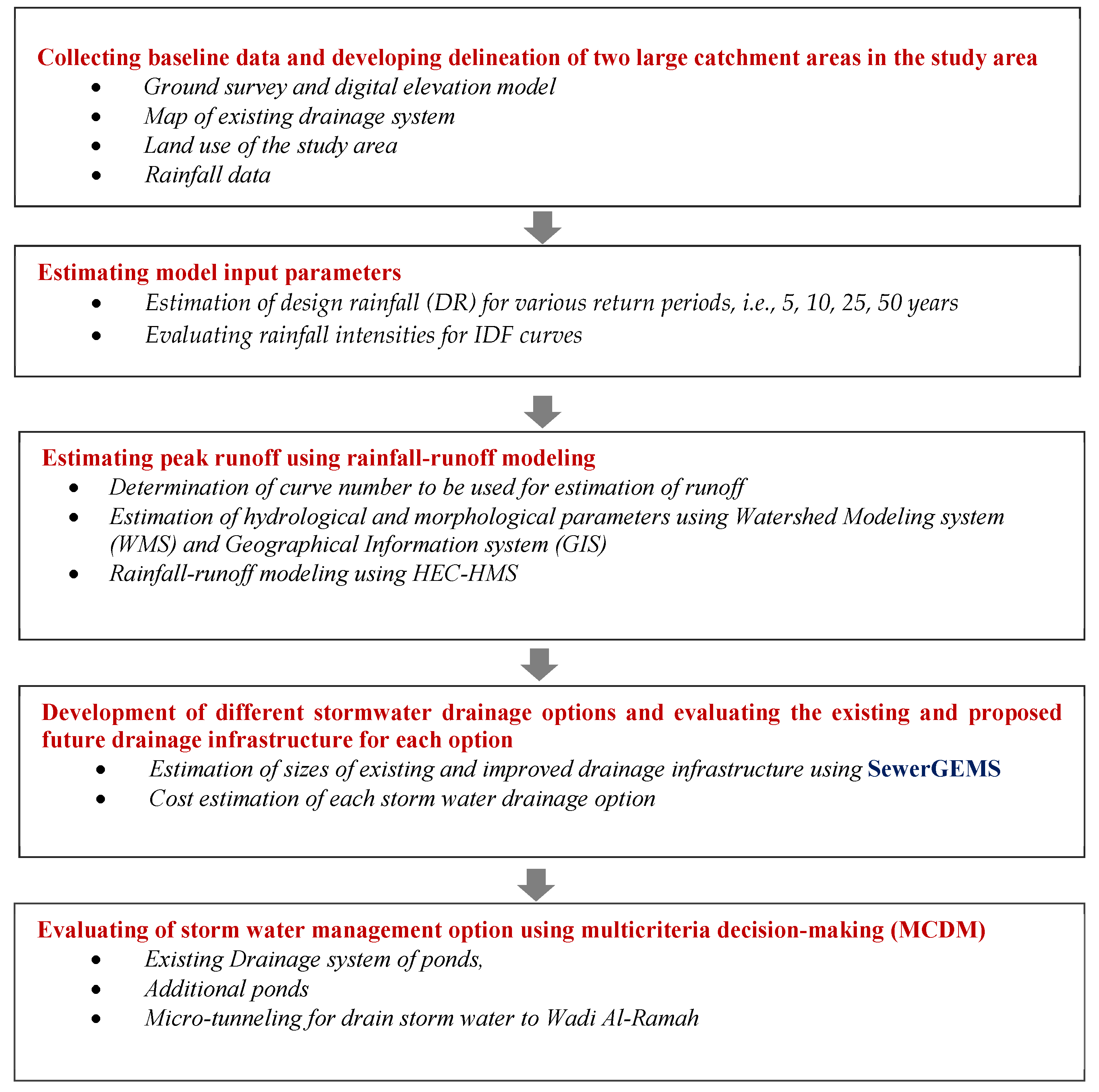
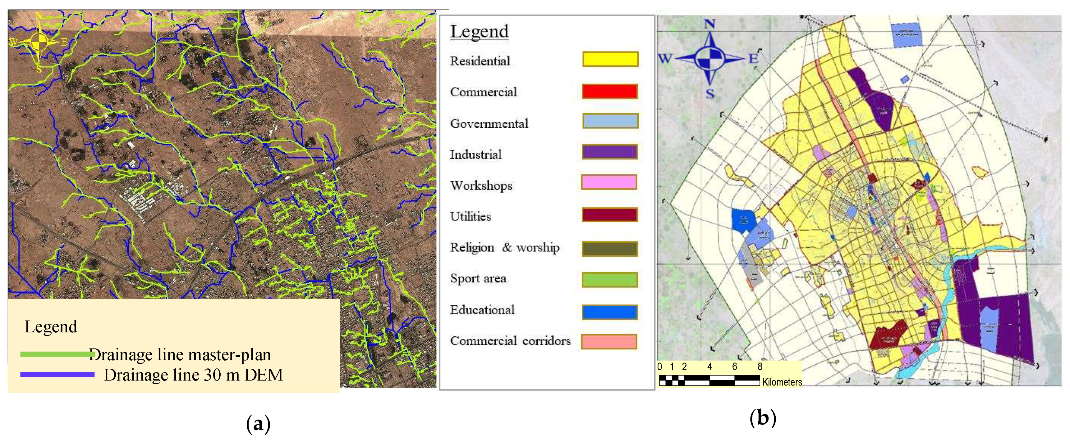
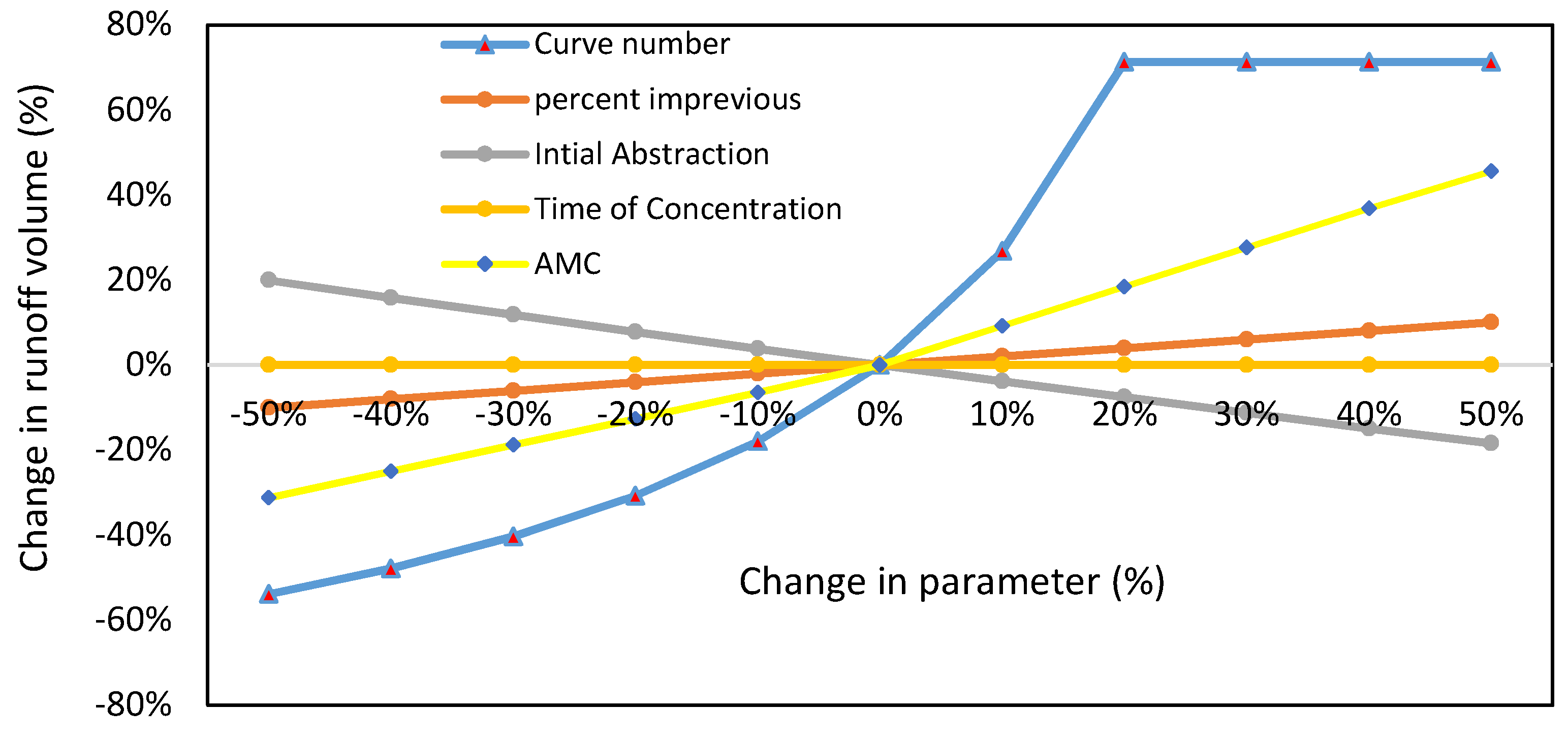
The framework developed in this research effectively answers all the three above posed questions. A methodology is established and implemented for optimal design of stormwater infrastructure by estimating the peak runoff through rainfall-runoff modeling in urban areas of high intensity/low frequency-flash floods. Present research also evaluates the impact of the geomorphological parameters (e.g., area of catchment, length of main drainage line, sub-areas under different land use etc.) obtained from two different data sets (30 m DEM and actual survey data) on the results of hydraulic modeling. HEC-HMS, geographical-information-system (GIS), and SewerGEMS software have been used for hydraulic modeling of different stormwater drainage options. Finally, Multi-criterion decision making (MCDM), consisting of Analytic Hierarchy Process (AHP) and Preference Ranking Organization Method for Enrichment Evaluation (PROMETHEE II), has been used to find the answer of the third research question.

2. Materials and Methods

2.1. The Framework

A brief methodology is presented in the framework developed in this research as given in Figure 2. Baseline data were gathered from the Municipality of Buraydah, including ground survey, digital elevation model (DEM), maps of existing drainage system, rainfall records, and land use map of the study area. Raw data were processed to generate different inputs required for the rainfall-runoff modeling and MCDM. The inputs were analyzed to determine the design rainfall, curve number, geomorphological and hydrological parameters, and the surface runoff using HEC-HMS software. Subsequently, different potential storm water management options were developed and hydraulic modeling was performed for each option using SewerGEMS software. Finally, each drainage option was evaluated for its feasibility in terms of flood risk, cost, environmental impacts, and technical constraints using MCDM.

2.2. Study Area

Buraydah, the regional capital of Al-Qassim Region is located on the north edge of Wadi Al Rumah which is the longest valley in KSA. Al Rumah wadi originates from Al-Medina and covers a long distance up to Sands of Althwairat with a length of approximately 600 km. Buraydah is located at the latitude and longitude of 26°21′33.23” N and 43°58′54.52” E. Due to the availability of groundwater, Al Qassim has been characterized as an important agricultural region in KSA. The city of Buraydah falls within the desert climate, which is characterized by the cold winters with rare but high intensity rains and the hot summers with low humidity [18,19]. During daytime the temperature ranges from 43 °C to 48 °C and during night it ranges from 32 °C–36 °C in summer. According to a recent survey, the population of Buraydah is about 616,000 which is nearly 52% of the entire population of Al-Qassim Region [20].

2.3. Development of Topographic and Morphological Maps

Topographic maps with scale 1:50,000 (i.e., DEM of actual survey), flood plain map, and photogrammetric survey formed the basis for principal planning and determination of the paths of wadies inside and around the Buraydah city. On ground field survey (actual survey) was performed during 2017 by the Municipality of Buraydah using geographical position system (GPS) with an accuracy of 2 cm. These actual survey data were also collected and used to audit the storm water drainage lines. The delineation was made on the basis of these maps and actual data by using engineering and hydrologic programs like (WMS) and (ArcGIS). The base map of Buraydah obtained from data processing is shown in Figure 3a,b shows the storm water stream paths in Buraydah based upon actual survey data. It shows that the streams flow from north to south towards Al Rumah wadi. The urbanization, expansion of city and existence of small hills interrupt the natural flow paths of storm water which otherwise is supposed to be disposed-off into Al Rumah wadi (see Figure 4).
In Figure 4, the red lines show hills and the ground levels written in red color show that how the runoff from the study area will be obstructed by the hills. This situation creates the problem of flooding in various areas of Buraydah. Some examples of flooding events in recent past are shown in Figure 5a,b. One of the drainage options to be considered in this research is to propose some additional ponds to accommodate the runoff from increased area due to development of the city. The proposed and existing ponds in study area are also shown in Figure 4.

2.4. Hydraulic Modelling of Stormwater Drainage System

2.4.1. HEC-HMS and GIS

HEC-HMS is a rainfall-runoff modeling software developed by the Hydrologic Engineering Center, 609 Second Street, Davis, CA, USA. HEC-HMS has multiple options to estimate surface runoff and the rainfall losses using various types of rainfall-runoff models. For determination of catchment parameters calibration of distributed models is required, which needs long records of runoff. This type of data is not available in most of the arid environmental regions. However, advancements in satellite imaging and geographical information system (GIS) tools have introduced geomorphological parameters that can be used to estimate the runoff from catchments with scarce data [21,22,23].
Types of delineation methods and accuracy of digital elevation model (DEM) data have important role in estimation of geomorphological parameters. DEMs ranging from 90 m, 30 m and to a few m resolutions have been used by various researchers in hydrologic studies. It is proven that improving the quality/resolution of DEM the geomorphological parameters of hydraulic model are improved. The main geomorphologic parameters of rainfall runoff modeling include catchment area, topography, shape, slope and stream density, main stream length, main channel slope, channel storage, and stream order for estimation of runoff [24,25,26,27]. For an accurate estimation of runoff, this research has taken data from actual ground survey and have compared them to the DEM of 30 m resolution. The processed data from DEM was used as the input to HEC-HMS. Subsequently, HEC-HMS employs the curve number (CN) method techniques for estimation of rainfall losses and the direct runoff [11,12,25,28].
The Curve Number was determined from soil classification, land use, and GIS data, which were used in the estimation of the flow rates. The depth-duration curves for Buraydah, adapted from the Master Plan of Flood Mitigation for Buraydah City, were used to find the design rain for various return periods. On the basis of delineation and other GIS data, various parameters of hydrological model (HEC-HMS) were obtained separately from the two data sources (actual survey DEM and 30 m DEM).

2.4.2. SewerGEMS and GIS

SewerGEMS V8i allows the storm sewer design projects to be completed in a shortest possible time [29] with low costs and high efficiency. SewerGEMS V8i is a fully-dynamic, multi-platform (CAD, GIS etc.), storm sewer modeling software. All the storm sewer system elements can be analyzed in one package namely “the hydraulic design.” This package consists of computation of the transit/total flow and estimation of design parameters (slopes, diameters etc.) of network pipes. It generates the layouts, transvers/longitudinal cross sections of the pipe network, and reports displayed with state-of-the-art graphic system in AutoCAD environment. The designers can add labels, write dimensions of sewage networks, and obtain the drainage drawing of network.

2.5. Development of Stormwater Drainage Options

Based on the indigenous knowledge, practical experience, and physical evidence, three potential options for stormwater drainage have been selected for detailed evaluation: (i) existing drainage infrastructure and ponds for two main catchments of Buraydah, (ii) improved drainage infrastructure with additional ponds, and (iii) routing of stormwater from the city to Wadi Al Rumah through micro-tunneling. Existing and improved ponding systems were analyzed with the help of the results obtained from HEC-HMS and SewerGEMS. The tentative costs for all the options were estimated as per market rates.

2.5.1. Option 1—Existing Drainage System

The characteristics of existing eight (8) ponds in whole of Buraydah are shown in Figure 6. Four out of these 8 existing ponds are located in the study area. The locations of four existing and seven proposed ponds in the study area are illustrated in Figure 4. No additional efforts/costs will be required for existing ponds. The entire drainage system was evaluated with the help of SewerGEMS for two main catchments of Buraydah, namely Al Naqaa and Al Khaleej.

2.5.2. Option 2—Additional Ponds

The two main (largest) catchments of Buraydah, i.e, Al Naqaa and Al Khaleej, have been investigated with an intention to improve the existing drainage infrastructure by providing additional ponds. Three main factors were considered for selection of suitable locations for additional ponds: (i) topography and the elevations of sub- areas of catchments, i.e., a pond should be located at the lowest elevation in the catchment; (ii) drainage lines and the flow directions; and (iii) availability of required land.
Three ponds for Al Naqaa and four for Al Khaleej have been proposed as shown already in Figure 4. Detailed analysis was conducted using GIS tools to generate the sub-catchments. These maps were integrated with SewerGEMS for analysis and design of proposed sewer network and the ponds.

2.5.3. Option 3—Drainage of Stormwater from Buraydah to Al Rumah Using Micro-Tunneling

Micro-tunneling is a well-known digging technique in which small tunnels are constructed with the help of remotely operated micro tunnel boring machine. As the study area consists of rolling terrain with small hills, placement of drainage pipes with the use of micro-tunneling was found to be a potential option with minimal environmental and social impacts during the construction phase. These drainage pipes will collect the stormwater with longer return periods from the main outfall sewers to safely route it to Wadi Al Rumah.

2.5.4. Evaluation of Stormwater Drainage Options

Feasibility of each stormwater drainage option depends on several influencing factors, including construction and operational cost, flood risk prevention, environmental impacts, and land requirements. Therefore, selection of the most feasible option is a multicriteria decision-making problem. These criteria are briefly described in the following.
Existing ponds will not require any additional cost, except for routine operation and maintenance expenditures. For proposed additional ponds and micro tunneling drainage system, tentative costs were estimated which are given in results and discussion section.
Ponds system holds serious concerns regarding their environmental impacts, e.g., possibility of surface and groundwater quality deterioration, loss of habitat, public health safety, vector breeding, etc. Storm water ponds are designed and constructed to retain the pollutants flushed off from non-point sources. Without proper maintenance, nutrients such as nitrogen and phosphorus can accumulate in the ponds which may lead to anaerobic conditions, algae production, unsightly conditions, and odors. Standing water in ponds can heat up during the summer months which can enhance all the water quality deterioration processes. Flushing of this poor-quality water during a larger flood will transfer the nutrients to the final receiving water body. Discharge of such effluent can cause long-term and significant adverse impacts on the natural surface water in the region.
The placement of large-sized ponds, particularly in low-lying areas, can cause nuisance to the existing residential areas. Year-round movement of the geese and mallards may become undesirable for the residents if structural complexity is not included in the pond design. A few inches of standing water can become mosquito-breeding areas. Standing water in permanent ponds often causes public concern for children playing in and around the pond. The drainage of storm water from Buraydah to wadi Al Rumah through micro-tunneling has minimum environmental impacts as the water is conveyed through conduits to a natural wadi away from the residential area.
There is high flood risk for ponding system if the successive storm happens in the same week, before emptying the previous runoff from pond or in absence of pond emptying system. On the other hand, the drainage option 3 has minimum flood risk.
The ponding system provides a high suitability for phased construction. It is suitable to any funding plan to serve an urban area with storm drainage ponding system. However, the micro-tunneling drainage system has a moderate suitability to be segmented as its construction should be started from downstream to upstream towards the first district that can be served by micro-tunneling drainage line. And then other districts can be served from downstream to upstream in future stages.

2.6. Multicriteria Decision-Making (MCDM) Methods

Evaluation of potential stormwater drainage options using MCDM analysis entails two primary steps: (i) estimation of criteria weights and (ii) aggregation of criteria scores for final ranking of options. Accordingly, the Analytical Hierarchy Process (AHP) and Preference Ranking Organization Method for Enrichment Evaluation (PROMETHEE II) have been used in this research for criteria weight estimation and aggregation respectively.

2.6.1. Analytic Hierarchy Process (AHP)

The AHP has been used to formulize the human-instinctive-understanding of a complex problem or to determine the weights of multicriteria [30]. Its application in the field of water resources management is widespread [31,32]. The process initiates with the development of a pairwise comparison matrix in which the preferences for the selected evaluation criteria are given by the experts. The degree of preference [33,34] as given in Table 1 has been used in this research.
In the subsequent step, a normalized-comparison-matrix is organized by dividing each value of pairwise-comparison matrix by the sum of the corresponding column. The corresponding rating (weights “w”) are determined by averaging the values in each row of the normalized matrix. Finally, analysis is conducted to check whether an acceptable inconsistency exists in the preferences given by the experts or not. Details can be seen in [32].

2.6.2. PROMETHEE II

PROMETHEE method [35] defines the preference functions built on the differences between attributes amongst various schemes. The main advantages of PROMETHEE method are (a) it is simplicity in calculations, (b) less influenced by concordance discrepancies and discrimination thresholds, and (c) requires relatively less calculation efforts as compared to other outranking methods, such as ELECTRE. Its advancement as PROMETHEE II provides total ranking of the options. Mathematical formulation of the method can be seen from [36].

3. Results and Discussion

3.1. Drainage Pattern Analysis

The results obtained from the delineation of 30 m DEM and the actual survey DEM are presented in Figure 7a. It shows the comparison between drainage lines obtained from the 30 m DEM and the actual survey data. A small difference between the two set of drainage lines can be seen in Figure 7a. Hence, as the actual survey data are highly expensive, the 30 m DEM can be used with reasonable accuracy in future studies where sufficient funds are not available. Nevertheless, when higher accuracy is a mandatory requirement the actual survey DEM should be used for parameter estimation.
The results from application of GIS show that Al Khaleej ponding system has a catchment area of 2398 hectares while the Al Naqaa ponding system covers about 2036 hectares. To convey the flow from this catchment to Wadi Al Rumah on the downstream of Al Khaleej and Al Naqaa catchments, the maps with drainage lines and extended boundary shown in Figure 3a and Figure 7a were analyzed. Certainly, the main drainage lines were used to convey the flows from all the catchments that lie in the path of the main drainage line of each of the main catchment. In this way the total drainage area of Al Naqaa catchment was approximately found to be 3981 ha. It will increase by about 40% as compared to the existing catchment area. In case of Al Khaleej the total area will become 3722 ha (45% increase).

3.2. Hydrologic Model Parameters

The results of using ArcGIS for land use are shown in Figure 7b. The values of various model parameters obtained are listed in Table 2 and Table 3. It can be observed that the difference of up to only 4.5% occurs in one or two parameters due to use of different resolution DEM. Most of the model parameters have negligible difference in values obtained from 30 m and actual survey data.

3.3. Hydraulic Modeling

3.3.1. Calibration and Validation of Hydrologic Model

Storm events of 2008, 2011, 2013, and 2015 have been used for HEC-HMS model calibration and verification respectively. The records of observed complete hydrograph are not available, so the calibration and validation were performed on the basis of total simulated and observed volume of runoff. The error (% difference in observed and simulated volume) was found to be around 10%. The depth duration curve and the simulated hydrographs for calibration and validation are shown in Figure 8a,b. The rainfall event during 2008 was used for calibration and other three events (2011, 2013, and 2015) were used for validation. The depth-duration graph (Figure 8a) having a storm duration of 24 h has been prepared by using the records of rainfall from 1965 to 2009.

3.3.2. Sensitivity Analysis for Parameters Used in HEC-HMS

Sensitivity analysis is an important task in rainfall-runoff modeling to identify the most significant parameters regarding runoff estimation. Sensitivity analysis was performed for five parameters (SCS curve number, impervious percentage, initial abstractions, antecedent soil moisture, and the time of concentration), which were primarily used for calculating the runoff volume. The impact of these five parameters on the percent change in runoff volume for Al Naqaa catchment is shown in Figure 9. It can be observed that curve number is the most important parameter in rainfall runoff modelling.

3.3.3. Flood Modeling Using HEC-HMS

The calibrated and verified model was subsequently used to simulate flood hydrographs for 10, 25, 50 and 100 years return periods for both the Al Khaleej and Al Naqaa catchments. The design hydrographs simulated by HEC are shown in Figure 10a,d. In case of Al Khaleej, about a 2% difference in peak flow was observed between the results from 30 m DEM and actual survey DEM for the 25 years return period flood. A negligible difference of 0.5% was found in case of Al Naqaa catchment. The simulated volume (the area under the hydrograph) on the basis of 30 m DEM and actual survey DEM is given in Table 4. Acceptable differences of about 4.5% and 3.5% in volume have been noticed among the results of 30 m and actual survey DEM in the case of the Al Khaleej and Al Naqaa catchments, respectively.

3.4. SewerGEMS Analysis of Stormwater Drainage Options

Hydraulic models were created using SewerGEMS (8Vi) to obtain the required analysis and design the proposed drainage system. Sample maps and design results as an example of micro-tunneling option for both the catchments are presented in Figure 11a–d and Table 5. Similar analyses have also been conducted for the other two options. Based on the trends of flooding events in the recent past and possibility of high floods in future due to changing global climatic conditions (refer to Figure 1), the 25-year storm was found to be rational and thus used for the design and analysis of ponds. This was chosen by further consulting the local authorities and engineers. Most of the responsible authorities in Qassim Region are recommending 25 years return period for design of stormwater drainage infrastructure in future. The results of SewerGEMS regarding runoff from hydraulic model for pond systems are presented in Figure 12a,b and Figure 13. As per detailed design for Al Naqaa catchment, the existing main line is adequate to route 10 years of flood, and the existing sub networks are adequate to accommodate five years of storms. Although, the existing main line in Al Khaleej catchment is adequate for 25 years of storm events, the existing sub networks can handle only five years of storm.
These findings support the objectives of present research that the capacity of entire network should be investigated by paying particular attention to each sub-catchment for accurate estimation of flood risks which generally was not given appropriate attention in past studies as it is a highly time consuming and tedious task. The design and analysis for 3rd option (i.e., micro-tunneling) was conducted for 25 years return period floods. Finally, the results of SewerGEMS were used to estimate costs of various options. The tentative cost estimates are attached as Appendix A.

3.5. Evaluation of Stormwater Drainage Options Using MCDM

All the three stormwater drainage options are different from each other in terms of their flood risk, cost, environmental impacts, and technical constraints. Therefore, MCDM analysis has been performed using the AHP and PROMETHEE II methods. The results are briefly described in the following paragraphs.
All the criteria were quantitatively judged by the experts based on the linguistic terms and their corresponding scores given in Table 6. Step-by-step procedure of PROMETHEE II application for ranking of potential stormwater drainage options is described below:
Based on the results of hydraulic modeling, cost estimates (Appendix A), and expert opinion, the decision matrix developed for three stormwater drainage options is presented in Table 7.
As all the criteria are the cost criteria, they were inversed. The pairwise comparison matrix for estimation of weights was developed using the methodology of AHP described in Section 2.6.1. The rating scheme given in Table 1 was used by four decision-makers from academia and the municipality of Buraydah. The geometric means of the ratings given by the decision-makers were calculated. The final estimated weights for flood risk, cost, environmental impacts, and technical constraints are 0.484, 0.272, 0.154, and 0.09 respectively. The values of consistency index (CI) and consistency ratio (CR) were found to be 0.019, and 0.02 respectively. A CR < 10% affirms the consistency check.
The methodology for the PROMETHEE-II method described in Appendix B was used to establish the preference index. Subsequently, a pairwise comparison was performed for all the options against each criterion using Equations (A2) to (A5). The multi-objective outranking index was calculated with the help of Equation (A6). The outgoing, incoming, and net flows were estimated using the Equations (A7) to (A9), and the results are presented in Table 8.
The final ranks for all the stormwater drainage options obtained from the application of AHP and PROMETHEE II methods presented in Table 8 show that the micro-tunneling (i.e., Option 3) outranked both the existing pond system (i.e., option 1) and the additional ponds option (Option 2). Hence the micro tunneling drainage system is found to be the most feasible options with acceptable flood risk, environmental issues, and cost.
Micro-tunneling can route the stormwater with acceptable flood risk. Environmental impacts, particularly associated to the modification of existing terrain that are expected to occur in case of improved ponds system, will also be minimal. Prior to practical implementation of the selected option, the results found in present study need to be validated by involving other stakeholders such as technical managers and engineers from water directorates and other relevant agencies. Public participation in the decision-making process is important for core public infrastructure projects. Hence, public opinion should be valued by conducting public hearings in the study area. Such initiative would be beneficial for improving awareness amongst the general public about the importance of limited available water resources and implementing water conservation strategies at large in KSA.

4. Conclusions and Recommendations

Stormwater drainage infrastructure in urban areas of arid environmental regions, such as Saudi Arabia, cannot safely route the stormwater for more than five years of floods. However, truck sewers in some areas can accommodate up to 25 years of floods. This practice is not sustainable under the present situation of water scarcity in the region when this valuable water is primarily lost due to evaporation. A methodology is needed to evaluate different stormwater management options for urban areas of arid environments.
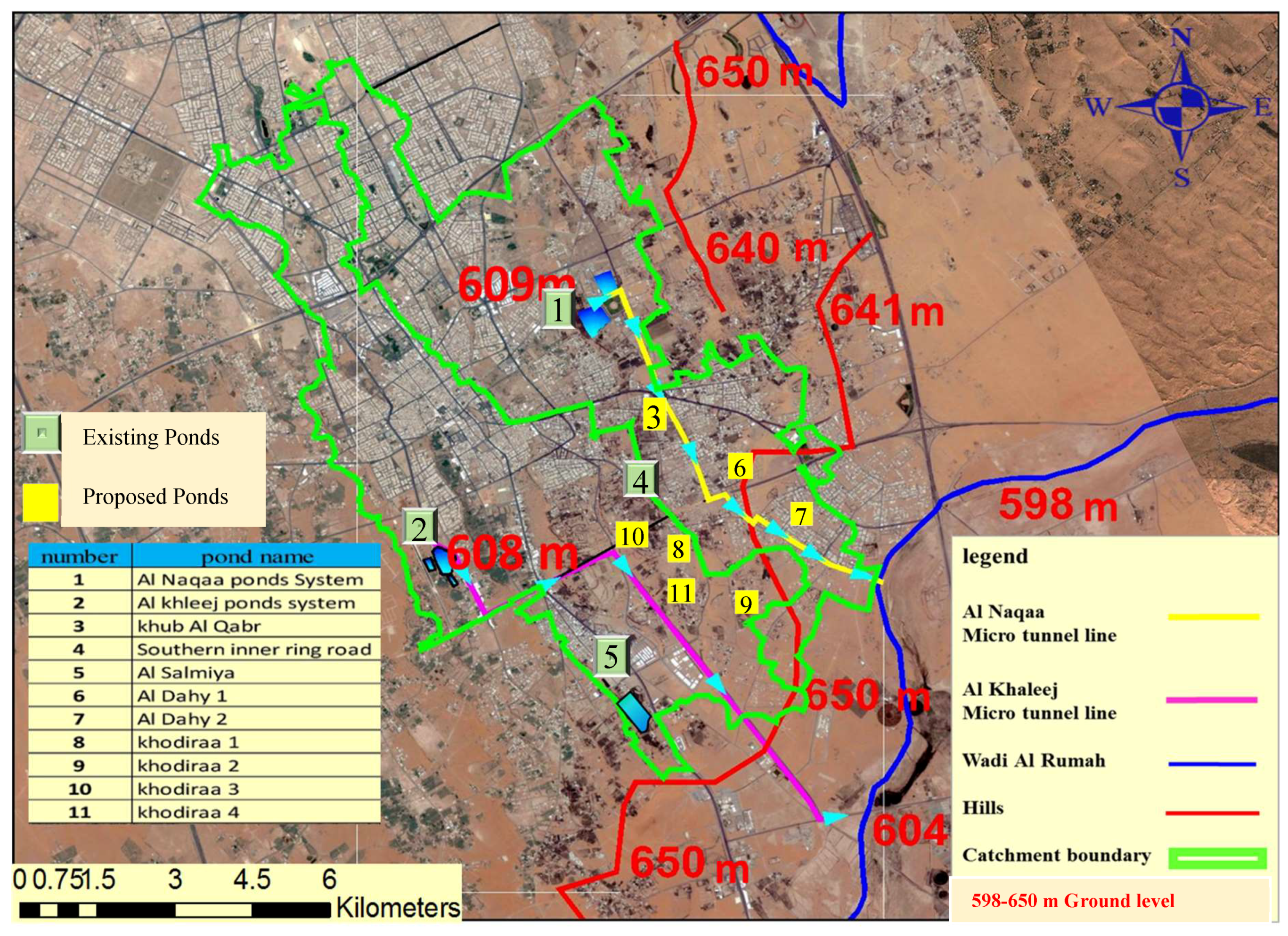
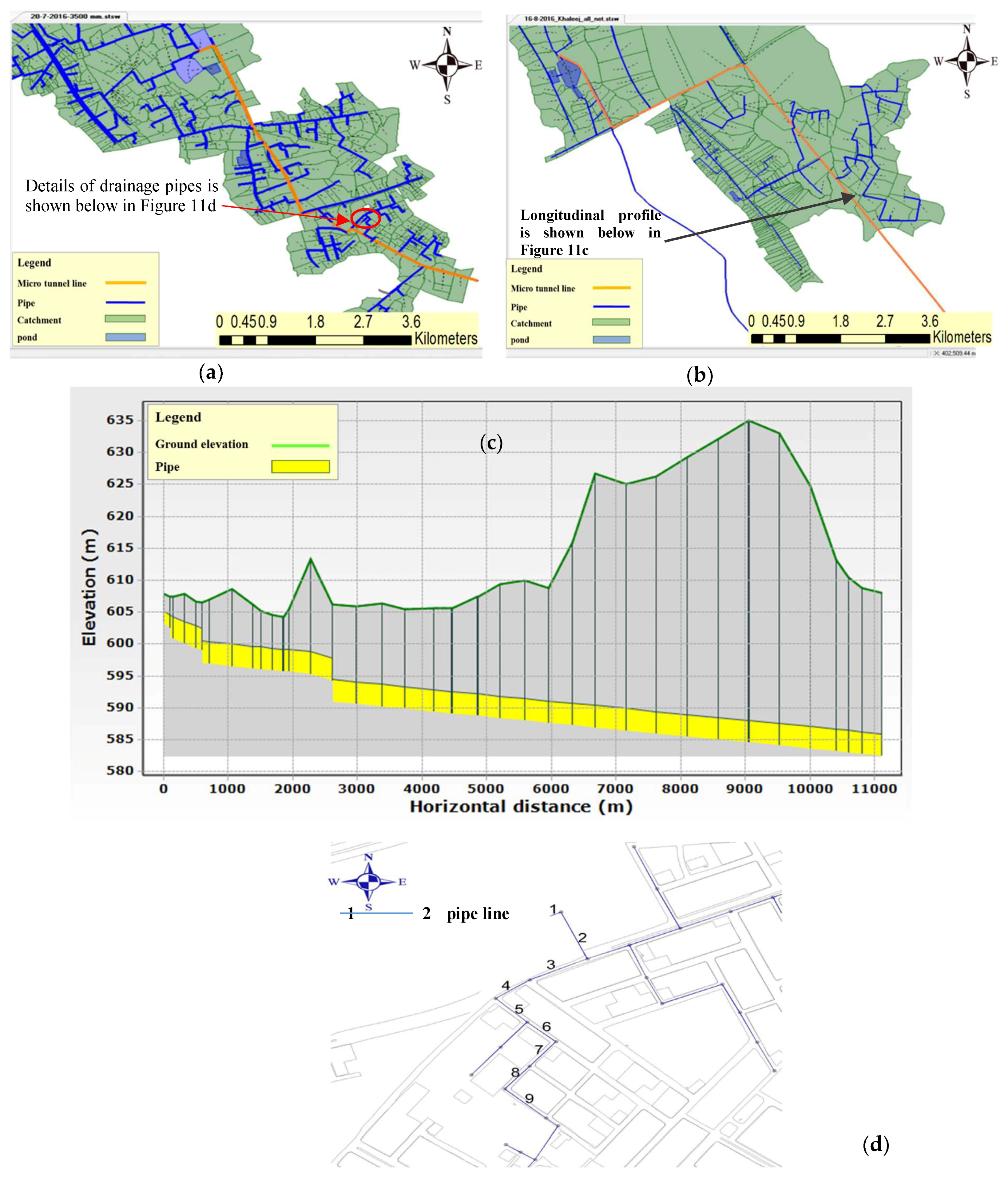
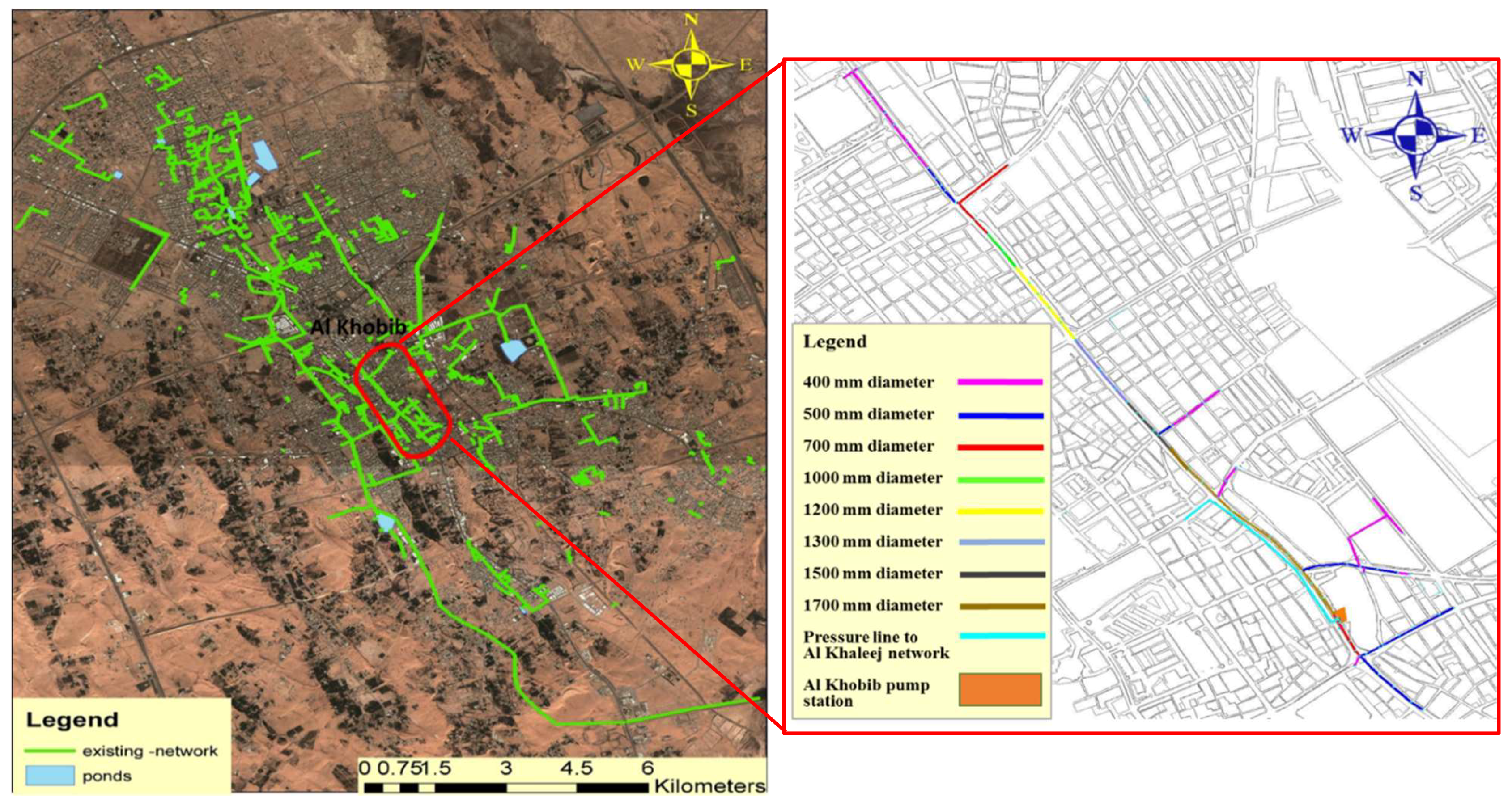
In this research, a methodology is developed for the design of the entire drainage networks in two urban catchments using state-of-the-art modeling techniques, such as HEC-HMS, GIS, and SewerGEMS. The proposed methodology revisits the design of drainage sub networks for higher return-period storms. The results of the hydraulic modeling of sewerage networks revealed that 30 m resolution DEM can be used with reasonable accuracy, particularly when expensive actual ground survey data is not available. Three stormwater drainage options, including the existing system, an additional ponds system, and micro-tunneling have been investigated for Buraydah, having wadies blocked due to city’s expansion and small hill barriers.
The stormwater drainage options have been evaluated using AHP and PROMETHEE II for multicriteria decision-making. Evaluation of all the options against the criteria of flood risk, environmental impacts, cost, and technical constraints revealed that the existing ponds system has high adverse environmental impacts regarding water quality, health, and being a source of mosquitoes. Based on the PROMETHEE II results, the micro-tunneling option outranked the other two due to minimal flood risk and environmental impacts (i.e., two criteria with higher importance weights established by AHP). Other sustainable options for flood risk management integrated with water conservation strategies can be investigated in future studies for arid environments. The study results should be validated before practical implementation of the micro-tunneling option by involving more stakeholders from water directorates, other relevant agencies, and public representatives.
Inclusion of a wider range of stakeholders (particularly the involvement of general public) can further improve the multicriteria decision-making process in the Gulf region. Such an initiative will enhance the sustainable development and implementation of water conservation strategies in KSA.

Author Contributions

Mohammad Alhumaid did modeling using SewerGEMS and HEC-HMS. Abdul Razzaq Ghumman supervised and checked the modeling results. Abdul Razzaq Ghumman also wrote the main body of the manuscript (except the MCDM part). Husnain Haider did modeling for MCDM and wrote this part of manuscript. Ibrahim Saleh Al-Salamah contributed in data collection and analysis. Yousry Mahmoud Ghazaw worked on the part of GIS.

Acknowledgments

The authors greatly appreciate the support of the Municipality of Buraydah for providing the baseline data. All the support provided by the Civil Engineering Department, College of Engineering, Qassim University is also acknowledged.

Conflicts of Interest

The authors declare no conflicts of interest.

Appendix A. Tentative Cost Estimates for Potential Stormwater Drainage Options for Buraydah City

Table A1. Total cost for micro-tunneling drainage system in Al Naqaa and Al Khaleej catchments.
ItemUnitCountCost (S.R)
Al Naqaa Catchment
Construction of drainage linem8510432,750,000
Construction of pumps station Piece1135,000,000
Total 567,750,000
Al Khaleej Catchment
Construction of drainage linem11,088507,600,000
Construction of pumps Station Piece1135,000,000
Total 642,000,000
Table A2. Land asset value of existing ponds.
No.Pond NameAsset Value (SR)
1Al Naqaa283,500,000
2Al Khaleej296,000,000
3Al Maslakh75,200,000
4Janoob Al Khaleej37,000,000
5Al Salmya24,270,000
Total715,970,000
Table A3. Total cost of pond system.
No.ItemTotal Cost (SR)
1Al Naqaa Catchment proposed532,238,690
2Al Khaleej catchment proposed189,062,000
3Existing ponds Land asset value715,970,000
Total1,437,270,690
Table A4. Cost of land acquisition and construction for Ponds.
Pond NameArea (m2)Land Acquisition Cost (S.R)Construction Cost (S.R)Total Cost (S.R)
Southern Inner Ring Road 83,600125,400,00017,556,000142,956,000
Khodiraa no. 160006,000,0001,260,0007,260,000
Khodiraa no. 213,50013,500,0002,565,00016,065,000
Khodiraa no. 3 740011,100,0001,406,00012,506,000
Khodiraa no. 420,00030,000,0003,600,00033,600,000
Al Mashtal126,700253,400,00025,121,000278,521,000
Saken Al Omal47,00094,000,0009,318,690103,318,690
Khub Al Qabr56,80056,800,00010,224,00067,024,000
Al Dahy no. 135,00035,000,0007,350,00042,350,000
Al Dahy no. 215,00015,000,0002,700,00017,700,000

Appendix B. Mathematical Formulation of PROMETHEE II

A pair-wise comparison of the option is made using preference functions to measure the difference between the options under a given set of criteria. For two options Ai and Ak, the preference functions can be written as
{ A i P A k i f f f h ( A i ) > f h ( A k ) A i I A k i f f f h ( A i ) = f h ( A k )
where, AiPAk describes that the option Ai is preferred over the option Ak, if the option Ai performs better than the option Ak regarding criterion h, and AiIAk defines that the options Ai and Ak are indifferent regarding criterion h, and iff (if and only if) is a bi-conditional logical connective between the statements.
PROMETHEE II offers a value between ‘0′ and ‘1′ to the preference relationship by introducing the preference function P(Ai, Ak) as
P   ( A i ,   A k ) = { 0 i f   f h ( A i ) f h ( A k ) P [ f h ( A i ) , f h ( A k ) ] i f   f h ( A i ) > f h ( A k )
where 0 < p[fh(Ai), fh(Ak)] ≤1. It is rational to assume for practical applications that
P [ f h ( A i ) , f h ( A k ) ] = P [ f h ( A i ) f h ( A k ) ]
Now, Dh(Ai, Ak) is the difference between the options Ai and Ak with regard to criterion h as
D h ( A i , A k ) = f h ( A i ) f h ( A k )
For selecting an explicit preference function, their six basic types were developed by [33]. The “usual preference” function considering absolute preference for any difference observed between the two options regarding a certain criterion is used here as
P [ f h ( A i ) ,   f h ( A k ) ] = { 0 i f D h ( A i , A k ) 0 1 i f D h ( A i , A k ) > 0
Next, the multicriteria preference index, π(Ai, Ak) and an integrated preference function of the option Ai over Ak for all the criteria can be written as
π ( A i ,   A k ) = i n W h P h ( A i ,   A k ) h = 1 n w h
where wh is the estimated weight of the criteria h. For developing the outranking relations amongst the options, the method proposed three outranking measures for each option, including outgoing flow (Ø+(Ai)), incoming flow (Ø(Ai)), and net flow (Ø(Ai)).
The “outgoing flow” described the way an option Ai outranks all the other options. An ideal action of the positive outgoing flow is 1.
+ ( A i ) = x M π ( A i ,   x )
where Ø+(Ai) is the outranking index of Ai, higher value of Ø+(Ai) shows greater dominance of Ai over the other options in the set M.
The “incoming flow” shows the way an option Ai is outranked by all the other options; an ideal action of incoming flow is 0.
( A i ) = x M π ( x ,   A i )
where Ø(Ai) is the outranked index for Ai, the lower value of Ø(Ai) shows smaller dominance by the other options over the option Ai in the set M.
Finally, the “net outranking flow” defines the balance between the outgoing flow and the incoming flow and established the complete ranking as
( A i ) = + ( A i ) ( A i )
where Ø(Ai) is the net ranking of Ai. The option having highest net flow Ø(Ai) will be considered as the least feasible stormwater drainage option.

References

  1. Chen, W.; Haung, G.; Zhang, H. Urban storm water inundation simulation based on SWMM and diffusive overland flow model. Water Sci. Technol. 2017, 76, 3392–3403. [Google Scholar] [CrossRef] [PubMed]
  2. Wang, M.; Zhang, D.Q.; Su, J.; Trzcinski, A.P.; Dong, J.W.; Tan, S.K. Future Scenarios Modeling of Urban Stormwater Management Response to Impacts of Climate Change and Urbanization. Clean-Soil Air Water 2017, 45, 1–10. [Google Scholar] [CrossRef]
  3. Noordwijk, M.; Tanika, L.; Lusiana, B. Flood risk reduction and flow buffering as ecosystem services Part1: Theory on flow persistence, flashiness and base flow. Hydrol. Earth Syst. Sci. 2017, 21, 2321–2340. [Google Scholar] [CrossRef]
  4. Zhu, Z.; Chen, X. Evaluating the Effects of Low Impact Development Practices on Urban Flooding under Different Rainfall Intensities. Water 2017, 9, 548. [Google Scholar] [CrossRef]
  5. Moglen, G. Hydrology and impervious areas. J. Hydrol. Eng. 2009, 14, 303–304. [Google Scholar] [CrossRef]
  6. Todeschini, S. Hydrologic and Environmental Impacts of Imperviousness in an Industrial Catchment of Northern Italy. J. Hydrol. Eng. 2016, 21, 05016013. [Google Scholar] [CrossRef]
  7. Tarawneh, Q.Y.; Chowdhury, S. Trends of Climate Change in Saudi Arabia: Implications on Water Resources. Climate 2018, 6, 8. [Google Scholar] [CrossRef]
  8. Sen, Z.; As-Sefry, S.; Al-Harithy, S. Probable maximum precipitation and flood calculations for Jeddah area, Kingdom of Saudi Arabia. Environ. Earth Sci. 2017, 76, 5. [Google Scholar] [CrossRef]
  9. Ali, K.; Bajracharyar, M.R.; Raut, N. Advances and Challenges in Flash Flood Risk Assessment: A Review. Geogr. Nat. Disasters 2017, 7, 195. [Google Scholar] [CrossRef]
  10. Almalki, A.A. Flood Mitigation in Jeddah, Saudi Arabia. Master’s Thesis, Voinovich School of Leadership & Public Affairs, Ohio University, Athens, OH, USA, 2017. [Google Scholar]
  11. Thomas, C. A Case Study of Runoff Coefficients for Urban Areas with Different Drainage Systems. Master’s Thesis, Water and Environmental Engineering Department of Chemical Engineering, Lund University, Lund, Sweden, 2017. [Google Scholar]
  12. Al-Zahrani, M.; Al-Areeq, A.; Sharif, H.O. Estimating urban flooding potential near the outlet of an arid catchment in Saudi Arabia. Geomat. Nat. Hazards Risk 2017, 8, 672–688. [Google Scholar] [CrossRef]
  13. Ewea, H.A.; Elfeki, A.M.; Al-Amri, N.S. Development of intensity–duration–frequency curves for the Kingdom of Saudi Arabia. Geomat. Nat. Hazards Risk 2017, 8, 570–584. [Google Scholar] [CrossRef]
  14. Tekeli, A.E. Exploring Jeddah Floods by Tropical Rainfall Measuring Mission Analysis. Water 2017, 9, 612. [Google Scholar] [CrossRef]
  15. Guizani, M. Storm Water Harvesting in Saudi Arabia: A Multipurpose Water Management Alternative. Water Resour. Manag. 2016, 30, 1819–1833. [Google Scholar] [CrossRef]
  16. Habibullah, A.M. Sustainable Strategies for Urban Water Management for Arid Region: The Case Study of Jeddah City Saudi Arabia. Master’s Thesis, University of Illinois at Urbana-Champaign, Urbana, IL, USA, 2014. [Google Scholar]
  17. Awadallah, A.G. Regional intensity-duration-frequency curves for Jeddah region, Saudi Arabia, using ordinary and L-moments approaches. J. Flood Risk Manag. 2015, 8, 195–207. [Google Scholar] [CrossRef]
  18. AlSaleem, S.S. Rainfall–Runoff Analysis for Sustainable Stormwater Drainage for the City of Madinah, Saudi Arabia. Arab. J. Sci. Eng. 2018, 43, 1955–1967. [Google Scholar] [CrossRef]
  19. Chowdhury, S.; Al-Zahrani, M. Characterizing water resources and trends of sector wise water consumptions in Saudi Arabia. J. King Saud Univ. Eng. Sci. 2015, 27, 68–82. [Google Scholar] [CrossRef]
  20. Chowdhury, S.; Al-Zahrani, M. Implications of climate change on water resources in Saudi Arabia. Arab. J. Sci. Eng. 2013, 38, 1957–1971. [Google Scholar] [CrossRef]
  21. Ghumman, A.R.; Al-Salamah, I.S.; AlSaleem, S.S.; Haider, H. Evaluating the impact of lower resolutions of digital elevation model on rainfall-runoff modeling for ungauged catchments. Environ. Monit. Assess. 2017, 189, 54. [Google Scholar] [CrossRef] [PubMed]
  22. Khidir, K.M.; Al-Sha’ar, M.T. Estimating Storm Direct Runoff Using Synthetic Unit Hydrograph Methods By (Wms) Model (Solag Basin As A Case Study). J. Univ. Duhok 2017, 20, 727–735. [Google Scholar] [CrossRef]
  23. Laks, I.; Sojka, M.; Walczak, Z.; Wróżyński, R. Possibilities of Using Low Quality Digital Elevation Models of Floodplains in Hydraulic Numerical Models. Water 2017, 9, 283. [Google Scholar] [CrossRef]
  24. Abdel-Fattah, M.; Saber, M.; Kantoush, S.A.; Khalil, M.F.; Sumi, T.; Sefelnasr, A.M. A Hydrological and Geomorphometric Approach to Understanding the Generation of Wadi Flash Floods. Water 2017, 9, 553. [Google Scholar] [CrossRef]
  25. Chandramohan, K.; Vijaya, R. Hydrologic Computations of SCS-CN, Rational, Area velocity and Tc Methods for Quantifying the Forest Surface Water Runoff—A case study in Sirumalai hill environs of Sathiyar Reservoir, Madurai, Tamil Nadu, India. Int. Res. J. Eng. Technol. IRJET 2017, 4, 662–670. [Google Scholar]
  26. Miller, K.; Clancy, K.F. Improving Curve Number Runoff Estimates Using Dual Hydrologic Soil Classification and Potential Contributing Source Areas Delineation Methods. J. Water Resour. Prot. 2017, 9, 20–39. [Google Scholar] [CrossRef]
  27. Al-Khafaji, M.S.; Al-Sweiti, F.H. Integrated Impact of Digital Elevation Model and Land Cover 2 Resolutions on Simulated Runoff by SWAT Model. Hydrol. Earth Syst. Sci. 2017. [Google Scholar] [CrossRef]
  28. Raj, A. Estimation of Runoff Using Curve Number Method and Its Modifications. J. Struct. Transp. Stud. 2017, 2, 1–9. [Google Scholar]
  29. Katti, M.; Krishna, B.M. Design of Sanitary Sewer Network using Sewer GEMS V8i Software. Int. J. Sci. Technol. Eng. 2015, 2, 254–258. [Google Scholar]
  30. Saaty, T.L. The Analytic Hierarchy Process, 1st ed.; McGraw-Hill: New York, NY, USA, 1980. [Google Scholar]
  31. Haider, H.; Al-Salamah, I.S.; Ghumman, A.R. Development of Groundwater Quality Index using Fuzzy-based Multicriteria Analysis for Buraydah, Qassim, Saudi Arabia. Arab. J. Sci. Eng. 2017, 49, 4033–4051. [Google Scholar] [CrossRef]
  32. Haider, H.; Sadiq, R.; Tesfamariam, S. Selecting performance indicators for small to medium sized water utilities: Multi-criteria analysis using ELECTRE method. Urban Water J. 2015, 12, 305–327. [Google Scholar] [CrossRef]
  33. Saaty, T.L.; Vargas, L.G. Inconsistency and rank preservation. J. Math. Psychol. 1984, 28, 205–214. [Google Scholar] [CrossRef]
  34. Vargas, L.G. An overview of the Analytic Hierarchy Process and its applications. Eur. J. Oper. Res. 1990, 48, 2–8. [Google Scholar] [CrossRef]
  35. Brans, J.P.; Vincke, P. A Preference Ranking Organisation Method: The PROMETHEE Method for Multiple Criteria Decision-Making. Manag. Sci. 1985, 31, 647–656. [Google Scholar] [CrossRef]
  36. Chinraj, V.K.; Hewage, K.; Haider, H.; Sadiq, R. Sustainability Evaluation Framework for Building Cooling Systems: A Comparative Study of Snow Storage and Conventional Chiller Systems. Clean Technol. Environ. Policy 2017, 19, 137–155. [Google Scholar]
Figure 1. Predicted change in precipitation in Qassim [7].
Water 10 00581 g001
Figure 2. Methodological framework for evaluating storm water drainage options in arid environments.
Water 10 00581 g002
Figure 3. Geographical maps of the city of Buraydah, (a) base map with extended boundary; (b) Paths of stormwater streams.
Water 10 00581 g003
Figure 4. Location of existing and proposed ponds in the study area. Boundaries of Al Naqaa and Al Khaleej catchments are defined by green colored lines, and overall topography is defined with the help of ground levels marked red.
Water 10 00581 g004
Figure 5. Photographs showing flooding in the city of Buraydah, (a) flood around King Fahd Hospital; (b) flooding on King Abdullah Road at its intersection with Ali Bin Abi Taleb Road.
Water 10 00581 g005
Figure 6. Characteristics of existing pond system in Buraydah City.
Water 10 00581 g006
Figure 7. Data used for hydraulic modeling, (a) Comparison of drainage patterns from 30 m digital elevation model (DEM) and the actual survey data; (b) Land use map for the City of Buraydah.
Water 10 00581 g007
Figure 8. Depth duration graph and hydrographs obtained as a result of calibration and verification of hydrologic model, (a) depth duration graph; (b) hydrographs for rainfall events during 2008, 2011, 2013 and 2015.
Water 10 00581 g008
Figure 9. Sensitivity analysis results of HEC-HMS model.
Water 10 00581 g009
Figure 10. Design hydrogrpahs generated from HEC, (a) runoff from 30 m DEM (Al Khaleej); (b) runoff from actual survey DEM (Al Khaleej); (c) runoff from 30 m DEM (Al Naqaa); (d) runoff from actual survey DEM (Al Naqaa).
Water 10 00581 g010
Figure 11. Hydraulic model prepared using SewerGEMS software, (a) Al Naqaa catchment; (b) Al Khaleej catchment; (c) Longitudinal profile of micro-tunneling option for Al Khaleej catchment and (d) Details of drainage pipes given in Table 5 (a part of Al Naqaa catchment).
Water 10 00581 g011
Figure 12. SewerGEMS results showing runoff from hydraulic model for pond systems, (a) volume of storm water at the Al Khaleej outlet; (b) volume of storm water at the Al Naqaa outlet.
Water 10 00581 g012
Figure 13. Existing storm sewerage network details.
Water 10 00581 g013
Table 1. Degree of preference to establish criteria weights.
ScaleDegree of PreferenceScaleDegree of Preference
1Equal importance7Very strong importance
3Moderate importance of one factor over another9Extreme importance
5Strong or essential importance
Table 2. Parameters of model obtained by using two sources (30 m DEM and actual survey data) for Al Khaleej.
Model ParametersDEM 30 ResolutionActual Survey DEM% Difference
Area (hectare)398138104.3
CN81.4981.490
Time lag (min)4103982.92
Impervious percentage %15.5015.400.62
Initial Abstraction11.611.540.52
Table 3. Parameters of model obtained by using two sources (30 m and actual survey DEM) for Al Naqaa.
Model ParametersDEM 30 ResolutionActual Survey DEM% Difference
Area (hectare)372235903.54
CN79.1879.180
Time lag (min)2902774.48
Impervious percentage %10.2101.96
Initial Abstraction13.513.40.74
Table 4. HEC-HMS results for Al Khaleej and Al Naqaa catchments using two sources of DEM.
Return PeriodVolume (m3)Peak Flow (m3/s)
30 m DEMActual Survey DEM30 m DEMActual Survey DEM
Al Khaleej Catchment
10 year586,700561,50012.912.6
25 year937,300897,00021.120.7
50 year1,264,4001,210,00028.928.3
100 year1,643,9001,573,0003837.2
Al Naqaa Catchment
10 year422,900407,90010.810.7
25 year715,200689,80019.0018.90
50 year995,300960,0027.126.9
100 year1,325,8001,278,80036.836.5
Table 5. The result of hydraulic analysis for a part of Al Naqaa catchment pipe drainage network.
Pipe-LabelDiameter (mm)Invert (Start) (m)Invert (Stop) (m)Length (Scaled) (m)Cover (Average) (m)Velocity (Maximum Calculated) (m/s)Slope (Calculated) (%)Section TypeMaterial
11400.00600.25600.1201.321.960.75CircleConcrete
21400.00602600.251101.882.11.591CircleConcrete
31200.00603602.21062.341.510.755CircleConcrete
41200.00603.5603692.071.490.725CircleConcrete
51200.00604.6603.5733.051.681.507CircleConcrete
61100.00607.4606.3643.911.991.718CircleConcrete
71100.00607.7607.4694.311.420.435CircleConcrete
81100.00608.6607.7642.411.381.406CircleConcrete
91100.00610608.79331.851.398CircleConcrete
Table 6. Linguistically define criteria scores.
Linguistic TermScoreLinguistic TermScore
Extremely low1Above average6
Very low2High7
Low3Very high8
Below average4Extremely high9
Average5Exceptionally high10
Table 7. Decision matrix for evaluation of stormwater drainage options.
Stormwater Management OptionsC1. Flood RiskC2. Cost (Construction and O&M)C3. Environmental IssuesC4. Technical Constraints
Option 1: Existing pond system8376
Option 2: Improved pond system7582
Option 3: Micro-tunneling2424
Table 8. Outranking relations using PROMETHEE II method.
FluxOption 1: Existing Pond SystemOption 2: Improved Pond SystemOption 3: Micro-Tunneling
φ+0.350.330.82
φ0.650.670.18
Net Flux−0.30−0.340.64
Rank231

